Georgia’s twenty-seventh county, Wayne County, was created in 1803 in the southeast part of the state on land acquired from the Creek Indians, who ceded the land to Georgia in the Treaty of Fort Wilkinson (1802). The 645-square-mile county is named after “Mad” Anthony Wayne, a general in the Revolutionary War (1775-83).
Early History
While Georgia was still an English colony, part of the area now forming Wayne County was located in St. David’s Parish. The area contained hundreds of acres of pine barrens and wiregrass country. Much of the land was undesirable for settlement by incoming whites, but some settlers arrived there as early as 1737, when records show that Jacob and Mary Musgrove set up a trading post at Fort Mount Venture. Georgia Rangers occupied the fort, which was located on the Sansavilla Bluff of the lower Altamaha River. In 1742 Yamasee Indians attacked and burned Fort Mount Venture, killing or imprisoning its occupants in what later became known as the Fort Mount Venture Massacre. Immigration by white settlers during the remainder of the eighteenth century was very slow, and by 1810 the population for the entire county was only 676. Many of the early white settlers were families who, having lost their bids to win richer land in Baldwin or Wilkinson counties in the 1805 land lottery, settled for the isolation and less desirable land offered by Wayne County.
Towns and Communities
The county seat, Jesup, was incorporated in 1870. Previously, the seat of government was located in the towns of Tuckersville and Waynesville, in turns. The historical record is indefinite about exactly when each of the two served as county seat between 1803 and 1856; maps and legislative reports often provide conflicting information. In 1856 the county’s residents voted for Waynesville as their seat of government, and it remained the seat until after the Civil War (1861-65), when the growth of Jesup led the state legislature to call for elections in 1873 to designate it as county seat.
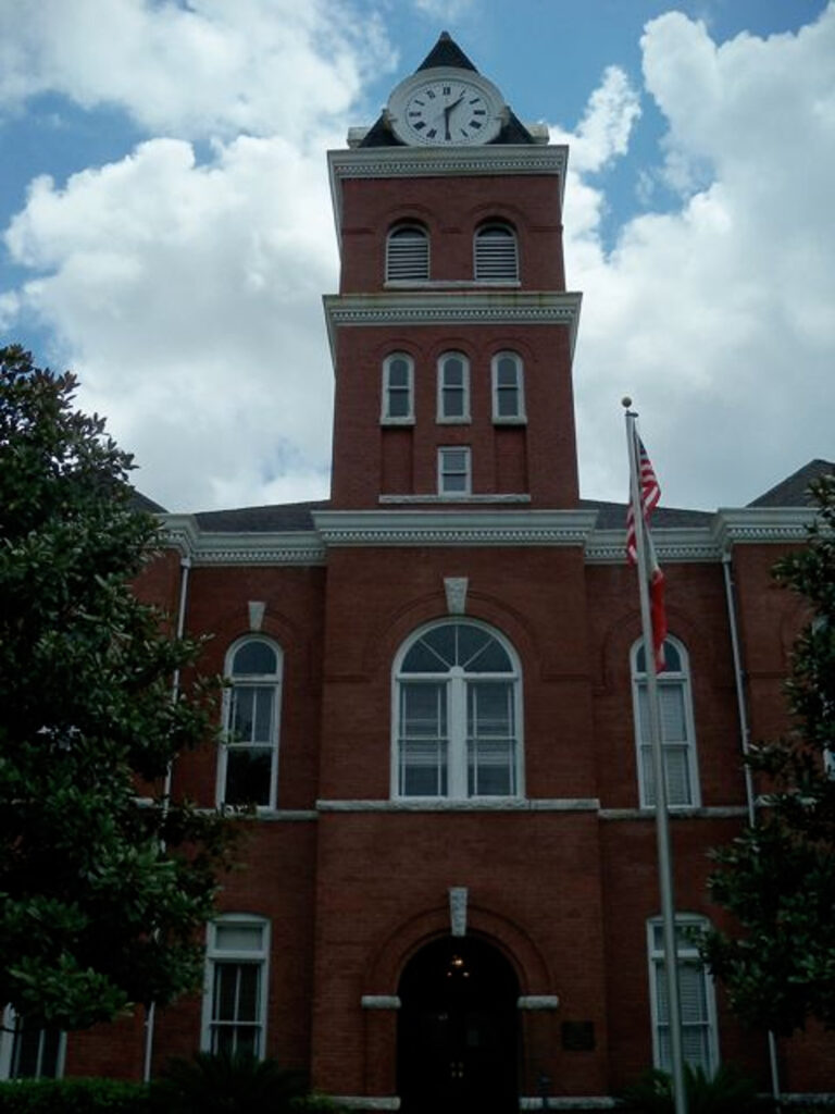
The first recorded courthouse was built in the woods northwest of Waynesville in 1860. The current courthouse, built in Jesup between 1902 and 1903, was listed on the National Register of Historic Places in 1980. Jesup sprang up around a station serving the Macon and Brunswick Railroad (later Norfolk Southern) and the Atlantic and Gulf Railroad (later CSX). Its name came from Thomas Jesup, a U.S. Army general famous for his exploits during the Creek Indian War of 1836. Jesup has often been referred to as “the town that trains built” because of the prominence of railroads in its history.
Two other incorporated towns are Odum and Screven. Odum, incorporated in 1907, was originally the site of a large sawmill. The town was first named Satilla. Screven, incorporated in 1907, was formerly known as Station Seven on the Atlantic and Gulf Railroad line. Unincorporated communities include Broadhurst, Doctortown, Gardi, Grangerville, Madray Springs, McKinnon, and Mount Pleasant.
Doctortown was established on the site of a former Indian settlement where a chief, Captain Aleck, had lived. (Aleck means “doctor” in the Creek language.) A post-Revolutionary stockade, Fort Defense, was the first white establishment in Doctortown. Before the Civil War, the town was a steamboat and railroad center with a sawmill. In 1864 Union general William T. Sherman, on his march to the sea, tried unsuccessfully to destroy the railroad trestle in Doctortown and retreated to the town of Midway. The trestle is still in use.
Gardi (pronounced “gar-dye”) is named after the Gardi Swamp. Two explanations have been put forth for the swamp’s name. One holds that it was for the Gardner family, whose signpost had broken off at the “n,” leaving what looked liked an “i,” while the other, more colorful account, claims that it was so named because adventurers to the swamp had to guard their eyes while penetrating the thickets. McKinnon began as a Finnish settlement in 1921.
Economy and Recreation
Wayne County has always relied heavily on forest products as an economic foundation. Early settlers tied logs into rafts, which they floated down the Altamaha River to the Georgia coast for processing. Later, railroads hauled the timber to its destination. Jesup, formed around a train station, is still a very active railroad town, and passenger trains continue to stop in town daily. The Wayne County Historical Society’s Heritage Center is located in a restored railroad section house. Logs that are not sent away very often end up in local pulpwood processing mills. In recent decades several new home developments, with a number of subdivisions designed to appeal to retirees, have been built in the area’s forests.

A large proportion of the county’s manufacturing jobs are related to the forest industry.
Wayne County offers plenty of opportunity for outdoor activity. The Altamaha River provides facilities for water sports, fishing, and camping, as does Lake Lindsay Grace, in western Wayne County. Three wildlife management areas, Little Satilla Wildlife Management Area, Rayonier Wildlife Management Area (shared with Brantley County), and Tyler Tract Wildlife Management Area, cover 105,000 acres of wilderness in the county.
According to the 2020 U.S. census, the population of Wayne County was 30,144.