The geological development of the Georgia coast and shoreline is the result both of ongoing, and geologically long-term, physical processes and of their interaction with a rapidly increasing population intent on settling and developing the most dynamic portion of the coastal zone.
Coastal Plain
The state is divided into five major physiographic provinces based primarily on geologic age and origin, topographic expression, and rock type (lithology). The boundary between the very ancient crystalline rocks of the Piedmont and the sediments of the Coastal Plain is marked by the fall line, the upriver point where navigation becomes difficult or impossible due to outcropping rocks and increased land slope.
The fall line also represents the inland edge of the oldest Coastal Plain sediments that were deposited in the sea of the Cretaceous period more than 100 million years ago. Tens of millions of years of Piedmont surface erosion provided sediment to the Cretaceous shoreline until the Coastal Plain built out and up to its present extent.
Although the Coastal Plain is the youngest province, it occupies more than half of the state’s land surface. The Coastal Plain is divided into upper and lower regions, the latter of which is distinguished by the ocean’s highest incursion during the geologically recent Pleistocene epoch, which began almost 2 million years ago.
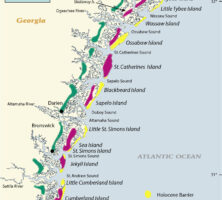
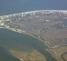
The Lower Coastal Plain extends inland for approximately sixty-five miles between the Savannah and St. Marys rivers and includes eleven counties. Within this region, the remains of six progressively higher and older shorelines are present, with features generally similar to those of the present coastline. These features were formed during Late Pleistocene interglacial high seas that occurred worldwide. Higher in elevation than adjacent land surfaces and river floodplains, these ancient sandbodies provided safer ground for early Indian occupation sites and trails, as well as for such modern cities as Brunswick, Folkston, Hinesville, Jesup, and Savannah. Transportation routes, including U.S. highways 17 and 84 and Interstate 95, are also partially located along these features. The Okefenokee Swamp owes its existence to Trail Ridge, a long sand spit that built southward across the mouth of what was once a large coastal embayment.
Courtesy of V. J. Henry
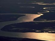
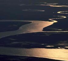
Barrier Islands
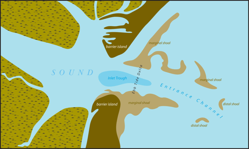
The modern (Holocene) Georgia coast is bordered by a series of relatively short, wide barrier islands separated by relatively deep tidal inlets, or sounds. Extensive sand shoal systems are present seaward of the inlets and central portions of the island.
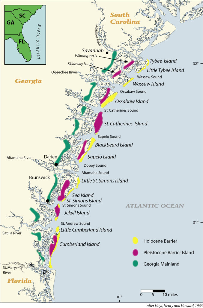
Eight major islands and island groups comprise the 100 miles of coast between the Savannah and St. Marys rivers. These are Cumberland/Little Cumberland, Jekyll, St. Simons/Sea Island/Little St. Simons, Sapelo/Blackbeard, St. Catherines, Ossabaw, Wassaw, and Tybee/Little Tybee. Tybee, St. Simons/Sea Island, and Jekyll are accessible by roadway and are the only developed barrier islands.
Popularly known as the Golden Isles, the barrier islands are composed of dune and beach ridge sands formed by the interaction of wind, waves, currents, sand supply, and a slowly rising or stable sea level. The availability of sand largely determines whether the shoreline will erode or build. In addition to providing natural habitat for numerous plant and animal communities, as well as recreational destinations for nearby human populations, the barrier islands protect the mainland from the brunt of major storms and hurricanes. The developed barrier islands have no such outer defense.
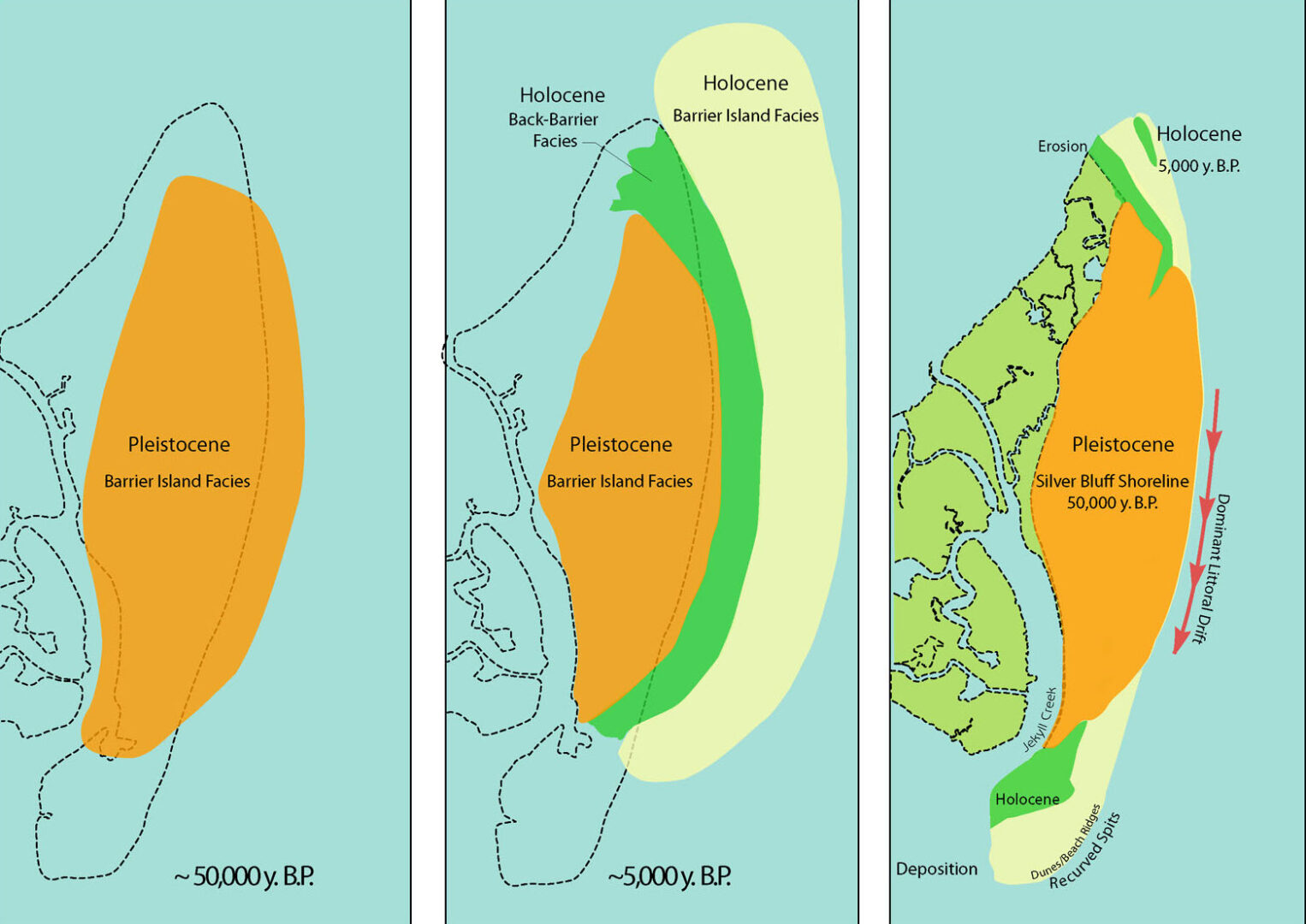
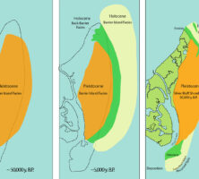
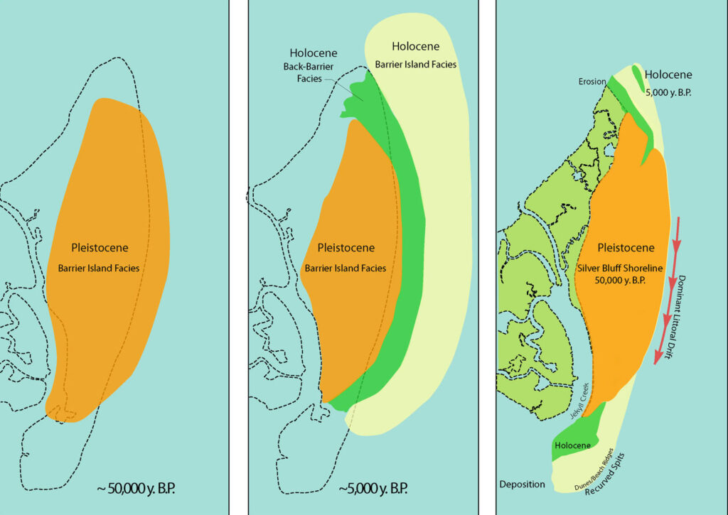
Six of the eight largest islands are composite barriers consisting of a core of beach and dune deposits formed during the previous, and slightly higher, worldwide sea level of the Pleistocene Silver Bluff, approximately 40,000 to 50,000 years ago. Most of the islands are closely fronted by similar deposits formed during the present, or Holocene, sea-level rise that began 15,000 years ago. At that time the shoreline was located along the edge of the continental shelf some seventy-five miles east of Brunswick, and the exposed sea bottom became an extension of the Coastal Plain with forests, plants, and animals. As the sea level began to slowly rise, animal communities were able to retreat from the rising sea, but forestlands were inundated.
Courtesy of V. J. Henry
About 5,000 years ago, the rate of sea-level rise decreased from three feet per century to a little less than a foot per century. The Holocene barrier islands began to form at, or near, their present locations and, in most cases, welded onto the Pleistocene barriers. Only vestiges of the Holocene barriers remain on Cumberland, Jekyll, and St. Catherines islands, the major portions having been eroded away by the slow but inexorable rise of the sea.
Coastal Processes
With the exception of wave action associated with seasonal storms (nor’easters) and infrequent hurricanes, the tide’s twice-daily ebb and flow is by far the dominant physical process along the Georgia coast. Because of the concave shape of the shoreline and a broad, shallow continental shelf, wave energy is low with wave heights averaging from two to less than four feet at the breaking point.
Prevailing onshore winds are from the northeast and southeast, whereas prevailing offshore winds are from the northwest and southwest. On the eastern coast of the United States, the prevailing alongshore current and sediment transport is from north to south. However, summer wind conditions frequently cause a south to north nearshore sediment transport. (It should be noted that current direction relates to destination, while wind direction relates to origin.)
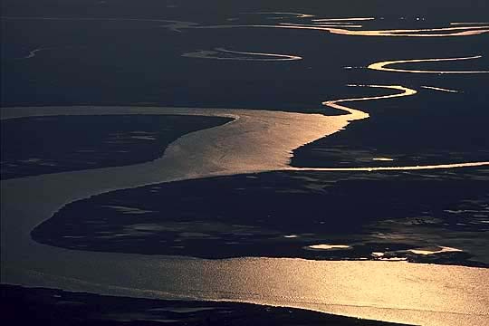
The average tidal range is just higher than six feet. Seasonal spring (biweekly) tides range up to ten feet and are the highest along the U.S. South Atlantic coast. The geological development of the Georgia coast is profoundly influenced by the large, but cyclic, storage capacity of the tidal marshlands behind the barrier islands. Powered by the six- to ten-foot tides, nearshore waters are forced in and flushed out of the sounds through the constricted inlets between the barrier islands.
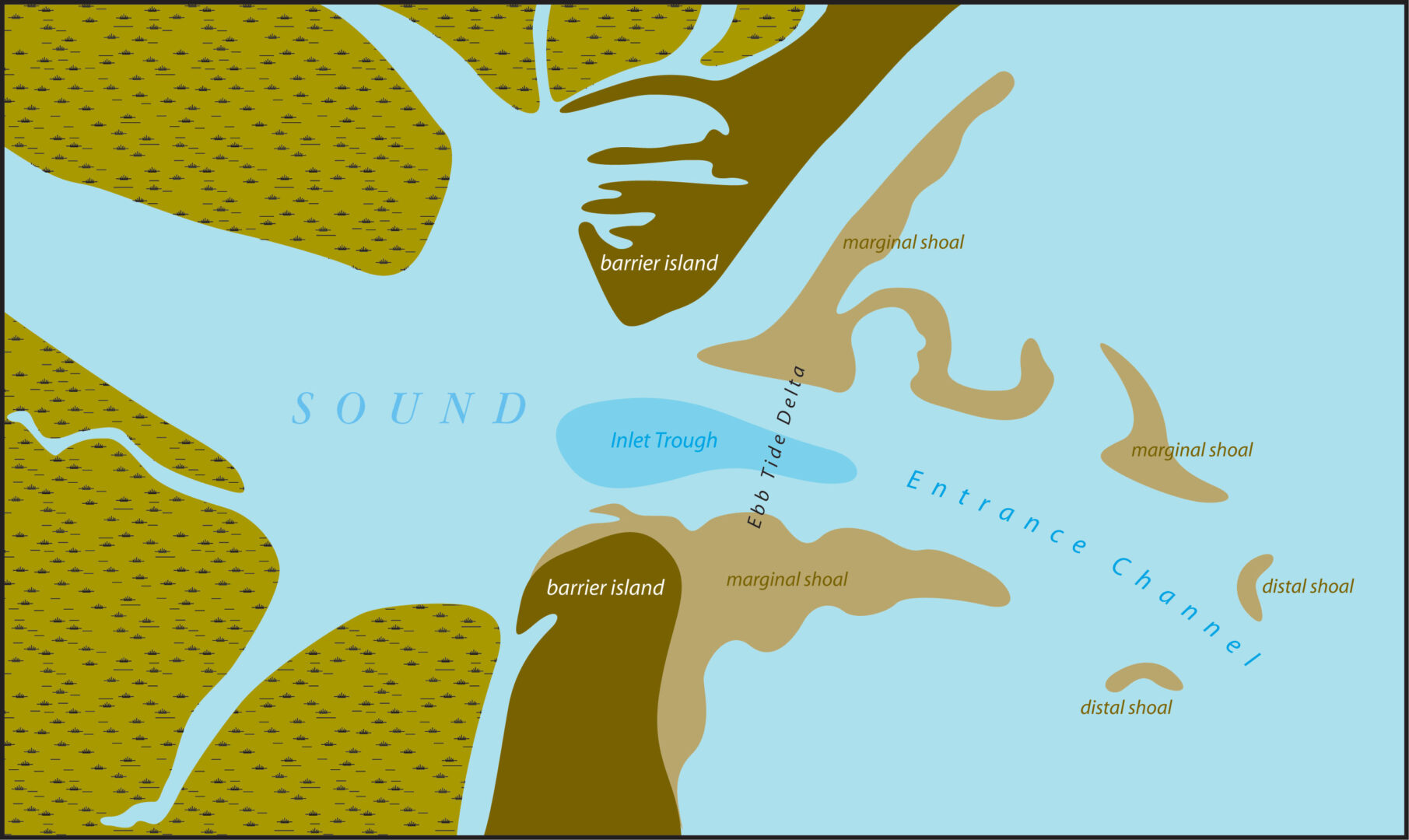
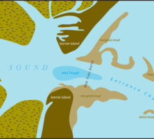
The flooding tide brings sediments into the back barrier areas, causing a slow but widely distributed buildup of the tidal marshlands. Conversely, the sudden loss of carrying capacity upon entering the open ocean causes the ebbing tidal currents to deposit the coarsest sediments just seaward of the inlet, thus forming an arcuate, or bowlike, pattern of shoals, which are collectively called an ebb-tide delta. Seasonal wave action modifies shoal and shoreline morphology and, together with prevailing currents, determines the direction and extent of sediment transport.
Courtesy of V. J. Henry
Ebb-tide deltas, inlets, and relatively short, wide barrier islands are associated with tide-dominant, low-wave-energy coasts. Flood-tide deltas, which form in the interior of the inlets, together with long, narrow barriers that have few inlets, are associated with wave-dominant, low-tidal-range coasts, such as those along Texas and North Carolina.
The coastal sand-sharing system consists of the ebb-tide delta; the alongshore, downcurrent drift of sediment; and the adjacent dynamic beach and dune system. Under natural conditions, the ebb-tide delta is slowly skewed downcurrent, and its southern component welds onto and nourishes the northern, or upcurrent, portion of the adjacent barrier island. Thus the inlet/alongshore drift system passes, or shares, sand from upcurrent sources to downcurrent recipients. Any interruption of this flow of sand, including inlet dredging, jetties, shoreline armoring, and so on, results in the starvation and erosion of downcurrent shorelines.
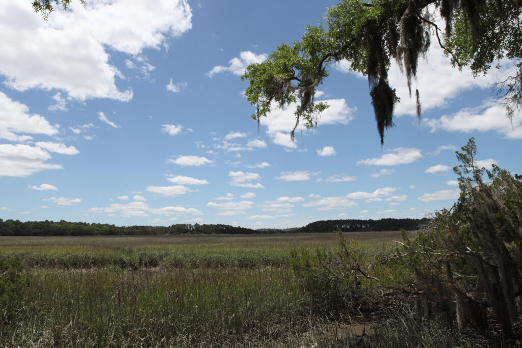
Tidal Marshlands
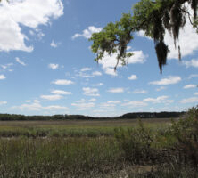
Georgia tidal marshlands include the saltwater Spartina sp. wetlands, which are predominant in the two- to five-mile-wide areas between the barrier islands and the mainland, and the brackish to freshwater wetlands, which extend inland along the estuaries for an additional ten miles or so.
Photograph by Steven Miller
Salt marsh vegetation consists chiefly of smooth cordgrass (Spartina alterniflora) in the widespread low marsh areas. The lower marshes are fringed by the needlerush (Juncus roemarianus), spike grass or saltgrass (Distichlis spicata), and glasswort (Salicornia spp.) in the higher marshland adjacent to marsh islands (hammocks) and the mainland.
The present marshlands developed over the past several thousand years, as the Holocene sea slowly rose to reoccupy the area behind the existing Pleistocene Silver Bluff barriers and the newly forming Holocene barriers. Marshland sediments consist primarily of river- and tide-borne sands, silts, and clays, in addition to a significant quantity of organic material contributed by indigenous plants and animals. The value of the tidal marshlands as a natural resource worthy of legal protection was recognized by the Georgia General Assembly’s passage of the 1970 Coastal Marshlands Protection Act.
Courtesy of Georgia Department of Economic Development.
Scattered throughout the tidal marshlands are numerous erosional remnants of Pleistocene and Holocene barrier islands and back barrier deposits. These are the vegetated hammocks, or back barrier islands, that because of increasing development pressure and the desire for overmarsh access have been the subject of recent study by the Georgia Department of Natural Resources Coastal Marsh Hammocks Advisory Council. According to the March 2002 council report, 1,200 hammocks, ranging in size from less than one acre to more than 1,000 acres, are located in the six shoreline counties.
History of Shoreline Change
Studies of the historical changes in the mean high-water shoreline of Georgia indicate that the primary causes of shoreline erosion are:
—The worldwide rise in sea level (an average of one to two feet per century);
—Seasonal storms and hurricanes. The Georgia coa st has not had a major hurricane (defined as at least a Category 3 hurricane) since the late 1890s;
—Man’s activities, including channel dredging with offshore disposal of dredged material, jetty construction, shoreline structures, and damming of rivers.
For the most part, the greatest shoreline change occurs along the northern (erosion) and southern (accretion) thirds of the islands. Although most island shorelines show only slight net retreat, large oscillations (several hundred feet or more) have occurred in the past. During the past seventy-seven years, the greatest net shoreline retreats have occurred on Tybee, St. Catherines, Wolf, and Jekyll islands.
The long-term trend of worldwide sea level rise dictates that shoreline erosion will increase. Where shorelines of the developed islands have been fixed by the emplacement of man-made structures, beach slopes have been flattened so that the time the beach can be used between high tides is greatly shortened. In order to have and retain a recreational beach, sand must be brought in from a nearby source. Such beach “nourishment” is costly and repetitious and often has negative environmental aspects.
Future Management of Georgia Coast
With the exception of Tybee, St. Simons/Sea Island, and Jekyll, the remaining Georgia barrier islands are undeveloped as a result of historical and current ownership, distance from the mainland, and, until recently, a relatively low mainland population density. However, along with the current population growth, there is increasing pressure from both the public and private sectors for more visitation to, and entrepreneurship on, state and federally managed islands. This condition is even more critical on the heavily populated coasts along the Eastern Seaboard of the United States.
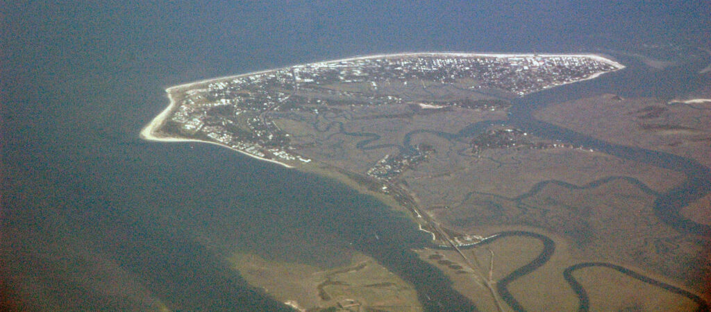
Image from James St. John
A 2003 Pew Oceans Commission Report states that more than half of the U.S. population resides in coastal counties comprising only 17 percent of the nation’s land area. This has resulted in a coastal population density almost five times the national average. According to a 2002 Pew Oceans Commission report, the national coastal population will increase 20 percent by 2015, amounting to a daily increase of 3,600 people.
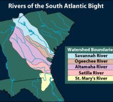
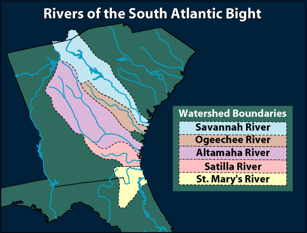
Following the national trend, Georgia’s coastal population grew by about 30,000, or about 5.5 percent, between 1998 and 2002. During this same period, the state population as a whole increased by an estimated 696,774 people, mostly in the Atlanta region. More specifically, the population growth in the eleven counties of the Georgia coastal zone between 1970 and 2000 was 210,505, an average increase of 16 percent per decade. Thus the coastal marshlands and estuaries are being affected by products and activities of the local population, as well as by those of a much larger portion of the state by way of the five major watersheds that empty into coastal estuaries.
Although the Satilla and St. Marys rivers contribute products derived only from the Coastal Plain, the Savannah, Ogeechee, and Altamaha watersheds extend into the Piedmont and beyond. The headwaters of the Savannah River are in North Carolina, for example, and the drainage basin of the Altamaha River begins in metro Atlanta. The divide between the aforementioned rivers, which flow into the Atlantic Ocean, and the Chattahoochee and Flint rivers, which flow into the Gulf of Mexico, begins in the vicinity of Peachtree Street.
Courtesy of V. J. Henry
In addition to an expanding resident population, the growing tourism industry creates an impact on coastal ecosystems. The National Oceanic and Atmospheric Administration estimates that coastal tourism and recreation account for 85 percent of all U.S. tourism revenues.
To effectively deal with population impacts as well as those caused by natural processes, decision makers and state management agencies must understand the processes, dynamic nature, and value of the Georgia coast.