

Georgia Quick Facts & Resources
Facts, figures, and fun from the New Georgia Encyclopedia
State Overview
General
- Colony
-
13th colony – February 12, 1733
- Statehood
-
4th state – January 2, 1788
- Capital
- Motto
-
“Wisdom, justice, and moderation”
- Nicknames
-
Empire State of the South; Peach State
- Total Population
-
10,711,908 – 8th most populous
Geography
- Latitude
-
30° 31′ N to 35°
- Longitude
-
81° W to 85° 53′ W
- Land Area
-
57,716.96 square miles
- Length & Width
-
300 mi. long × 230 mi. wide
- Coastline
-
100 miles
- Highest Point
-
4,784 feet
- Lowest Point
-
Sea level
- Geographic Center
Government
- Governor
-
Brian Kemp
- U.S. Congress
-
2 senators; 14 representatives
- Counties
-
159
- Electoral Votes
-
16
Climate
- Highest Recorded Temperature
-
112°F
- Lowest Recorded Temperature
-
-17°F
- Average Temperature
-
32.6°F – 92.2°F
Population
State Population by Decade
| Year | Total |
|---|---|
| 1790 | 82,548 |
| 1810 | 252,433 |
| 1820 | 340,989 |
| 1830 | 516,823 |
| 1840 | 691,392 |
| 1850 | 906,185 |
| 1860 | 1,057,286 |
| 1870 | 1,184,109 |
| 1880 | 1,542,180 |
| 1890 | 1,837,353 |
| 1900 | 2,216,331 |
| 1910 | 2,609,121 |
| 1920 | 2,895,832 |
| 1930 | 2,908,506 |
| 1940 | 3,123,723 |
| 1950 | 3,444,578 |
| 1960 | 3,943,116 |
| 1970 | 4,589,575 |
| 1980 | 5,463,105 |
| 1990 | 6,478,149 |
| 2000 | 8,186,453 |
| 2010 | 9,687,653 |
| 2020 | 10,711,908 |
20 Largest Cities by Population – 2020 Census
| City | Population |
|---|---|
| Atlanta | 498,715 |
| Columbus | 206,922 |
| Augusta-Richmond County | 202,081 |
| Macon-Bibb County | 157,346 |
| Savannah | 147,780 |
| Athens-Clarke County | 127,315 |
| Sandy Springs | 108,080 |
| South Fulton | 107,436 |
| Roswell | 92,833 |
| Johns Creek | 82,453 |
| Warner Robins | 80,308 |
| Albany | 69,647 |
| Alpharetta | 65,818 |
| Marietta | 60,972 |
| Stonecrest | 59,194 |
| Smyrna | 55.663 |
| Valdosta | 55,378 |
| Brookhaven | 55,161 |
| Dunwoody | 51,683 |
| Newnan | 42,549 |
20 Largest Counties by Population – 2020 Census
| County | Population |
|---|---|
| Fulton | 1,066,710 |
| Gwinnett | 957,062 |
| Cobb | 766,149 |
| DeKalb | 764,382 |
| Clayton | 297,595 |
| Chatham | 295,291 |
| Cherokee | 266,620 |
| Forsyth | 251,283 |
| Henry | 240,712 |
| Muscogee | 206,922 |
| Richmond | 206,607 |
| Hall | 203,136 |
| Paulding | 168,661 |
| Houston | 163,633 |
| Bibb | 157,346 |
| Columbia | 156,010 |
| Coweta | 146,158 |
| Douglas | 144,237 |
| Clarke | 128,671 |
| Fayette | 119,194 |
Metro Areas by Population – 2020 Census
| Metropolitan Statistical Area (MSA) | Population |
|---|---|
| Atlanta–Sandy Springs–Alpharetta | 6,089,815 |
| Augusta-Richmond (GA–SC) | 611,000 |
| Chattanooga (TN-GA) | 562,647 |
| Savannah | 404,798 |
| Columbus (GA–AL) | 328,883 |
| Macon-Bibb | 233,802 |
| Athens-Clark | 215,415 |
| Gainesville | 203,136 |
| Warner Robins | 191,614 |
| Albany | 148,922 |
| Valdosta | 148,126 |
| Dalton | 142,837 |
| Brunswick | 113,495 |
| Rome | 98,584 |
| Hinesville | 81,424 |
State Symbols
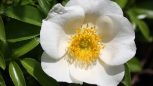
Cherokee Rose
State Flower

Quail
Game Bird

Brown Thrasher
State Song Bird

Live Oak
State Tree

State Vegetable

State Crop

State Fruit

Muscadine
State Grape

Gopher Tortoise
State Reptile

Green Tree Frog
State Amphibian
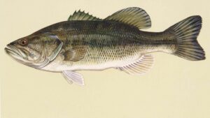
Largemouth Bass
State Fish
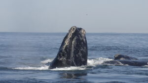
State Marine Mammal
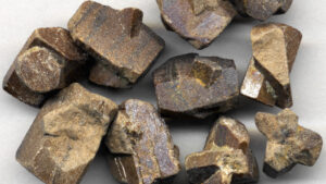
Staurolite
State Mineral

“Georgia on My Mind”
State Song
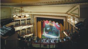
Springer Opera House
State Theatre

State Flag
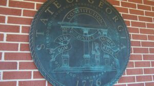
Great Seal
Geography
Major Lakes & Reservoirs
| Reservoir | Created | Builder | Purpose | Impounded | Acres |
|---|---|---|---|---|---|
| Lake Allatoona | 1950 | Army Corps of Engineers | Floor control | Etowah River basin | 12,010 |
| Lake Andrews | 1963 | Army Corps of Engineers | Navigation | Lower Chattahoochee River | 1,540 |
| Bartlett’s Ferry | 1926 | Georgia Power Company | Power | Middle Chattahoochee River | 5,850 |
| Lake Blackshear | 1930 | Crisp County Power Company | Power | Flint River | 8,700 |
| Black Shoals | 2000 | Big Haynes Creek Impoundment Authority | Water supply | Big Haynes Creek | 650 |
| Blue Ridge | 1930 | Tennessee Valley Authority | Power | Toccoa River | 3,290 |
| Lake Burton | 1919 | Georgia Power Company | Power | Tallulah River | 2,775 |
| Carters Lake | 1977 | Army Corps of Engineers | Power | Coosawattee River | 3,220 |
| Lake Chatuge | 1942 | Tennessee Valley Authority | Flood control, power | Hiwassee River | 7,050 |
| Lake Chehaw (Worth) | 1919 | Georgia Power Company | Power | Flint River, Muckalee Creek, Kinchafoonee Creek | 1,400 |
| Clarks Hill (J. Strom Thurmond) | 1954 | Army Corps of Engineers | Flood control, power | Savannah River, Little River | 71,535 |
| Walter F. George | 1963 | Army Corps of Engineers | Navigation, power, water supply | Chattahoochee River | 45,180 |
| Goat Rock | 1912 | Georgia Power Company | Power | Chattahoochee River | 940 |
| Lake Hartwell | 1963 | Army Corps of Engineers | Flood control, power | Savannah River | 56,000 |
| High Falls | unknown | Georgia Power Company | Grist mill, power, recreation | Buck Creek | 650 |
| Jackson Lake | 1910 | Georgia Power Company | Power | Alcovy River, South River, Yellow River, Tussahaw Creek | 4,750 |
| Lake Juliette | unknown | Georgia Power Company | Power (cooling water) | Rum Creek, Chambliss Creek | 3,600 |
| Lake Lanier | 1956 | Army Corps of Engineers | Water supply, Flood control, power, navigation | Chattahoochee River | 38,000 |
| Lake Nottely | 1942 | Tennessee Valley Authority | Power, navigation, flood control | Nottely River | 4,180 |
| Lake Oconee | 1979 | Georgia Power Company | Power | Oconee River, Apalachee River, Richland Creek, other creeks | 19,050 |
| Lake Oliver | 1926 | Georgia Power Company | Power | Middle Chattahoochee River | 2,150 |
| Lake Rabun | 1915 | Georgia Power Company | Power, water supply | Tallulah River | 834 |
| Richard B. Russell | 1983 | Army Corps of Engineers | Flood control, power | Savannah River | 26,650 |
| Lake Seminole | 1957 | Army Corps of Engineers | Navigation, power, recreation | Flint River, Chattahoochee River | 37,500 |
| Lake Sinclair | 1953 | Georgia Power Company | Power | Oconee River, Apalachee River | 15,330 |
| Lake Tobesofkee | unknown | Bibb County | Recreation | Tobesofkee Creek | 1,750 |
| Lake Tugalo | unknown | Georgia Power Company | Power | Tallulah River, Chattooga River | 597 |
| Lake Varner | 1991 | Newton County | Water supply | Cornish Creek | 850 |
| Weiss Lake | 1961 | Alabama Power Company | Power | Coosa River | 30,200 |
| West Point Lake | 1974 | Army Corps of Engineers | Flood control, power, navigation, recreation | Chattahoochee River | 25,900 |
20 Largest Counties
| County | Square Miles |
|---|---|
| Ware | 906.6 |
| Burke | 835.1 |
| Clinch | 824.2 |
| Laurens | 818.6 |
| Charlton | 783.0 |
| Camden | 782.5 |
| Emanuel | 690.4 |
| Bulloch | 688.9 |
| Washington | 684.4 |
| Screven | 655.7 |
| Wayne | 648.9 |
| Chatham | 646.3 |
| Decatur | 623.2 |
| Coffee | 602.7 |
| Liberty | 602.6 |
| Glynn | 583.1 |
| McIntosh | 574.8 |
| Worth | 574.6 |
| Colquitt | 556.6 |
| Thomas | 552.1 |
Web Resources
This interactive map provides census, geographic, and political information on each county in the state.
Album provides access to more than 16,000 photographs and audio and video recordings from the collection of the Kenan Research Center at the Atlanta History Center.
Atlanta Studies is an open access, digital publication that features original scholarship on Atlanta’s past and present. This multimedia web-based journal is published by the Emory Center for Digital Scholarship.
The ATLmaps platform, a collaboration between Georgia State University and Emory University, combines archival maps, geospatial data visualization, and user contributed multimedia location pinpoints to promote investigation into any number of issues about Atlanta.
The channel for the Walter J. Brown Media Archives and Peabody Awards Collection provides streaming content through various databases, including the archives’ website.
The CRDL promotes an enhanced understanding of the civil rights movement by helping users discover primary sources and other educational materials from libraries, archives, museums, public broadcasters, and others on a national scale.
The Digital Library of Georgia, an initiative of GALILEO, partners with the state’s libraries, archives, museums, and other institutions to provide access to key digital resources on Georgia history, culture, and life.
A project of GALILEO, this database contains born-digital publications and scanned print documents produced by Georgia state agencies from 1994 to the present. GGP participants are actively scanning documents printed before 1994.
A project of the Digital Library of Georgia, the Georgia Historic Newspapers Archives includes over one million digitized newspaper pages between 1786 and 1986.
This collection of videos, produced by Georgia Public Broadcasting, tells the stories of the state’s history and supports the Georgia Performance Standards for eighth-grade social studies.
The Virtual Vault provides electronic access to historic Georgia manuscripts, photographs, maps, and government records housed in the state archives.
Compiled by the Georgia Historical Society, this index provides location information, full text, and images of all the historical markers in the state.
Available via the Digital Library of Georgia, this collection provides 4,445 maps by the Sanborn Map Company depicting commercial, industrial, and residential areas for 133 Georgia municipalities. Fire insurance maps document the changing face of towns and cities, providing highly detailed information for each neighborhood and block.
A collaborative effort of the Georgia Archives and the Digital Library of Georgia, this collection features nearly 18,000 photographs, ranging from daguerreotypes to Kodachrome prints, that span more than 100 years of Georgia history.

