The Georgia Department of Transportation (GDOT) plans, constructs, and maintains Georgia’s network of highways and bridges, while providing planning and financial support for other transportation systems ranging from airports to mass transit and bicycle trails.
An agency of the state government, GDOT is overseen by a state transportation board that includes representatives from each of Georgia’s congressional districts. Based in the state office complex in downtown Atlanta, GDOT also operates seven district offices, in Cartersville, Chamblee, Gainesville, Jesup, Tennille, Thomaston, and Tifton. The department had approximately 3,700 employees and an operating budget of $4 billion in fiscal year 2022.

Long known primarily for highway construction and maintenance, GDOT has broadened its agenda to include other forms of transportation as well as the administration of traffic management systems to monitor and improve traffic flow. The department also provides administrative support to the Georgia Tollway Authority, the Georgia Rail Passenger Authority, and the Georgia Southwest Rail Excursion Authority.
Support for Georgia Roadways
As of 2021 GDOT operated the tenth-largest transportation system in the United States, with more than 50,000 lane-miles of interstate highways and state routes under its control. To maintain those roadways, GDOT receives the proceeds from the state’s motor vehicle fuel tax and state appropriations, as well as funds from the U.S. Department of Transportation. GDOT operates the following construction and maintenance programs:
The Governor’s Road Improvement Program (GRIP) supports a network of economic development highways that connect most of Georgia’s cities to the interstate highway system. The GRIP system will ultimately ensure that 98 percent of the state’s population is within twenty miles of a four-lane highway. As of 2023, 72 percent of the planned GRIP system was complete or under construction, about 2,382 miles of roadway. Some well-known examples of GRIP projects are the Golden Isles Parkway, the Fall Line Freeway, and the South Georgia Parkway.
The Local Maintenance and Improvement Grant Program (LMIG) helps local governments preserve their road systems by funding maintenance and improvement activities, such as road resurfacing or sidewalk construction. In 2010 it replaced the Local Assistance Road Program (LARP), which only funded maintenance. Each year, every city and county in the state is invited to submit a priority list of projects to the GDOT, which reviews requests and establishes priorities for maintenance and improvement.
The Surface Transportation Program (STP) is a block grant program that may be used for any roads not classified as local or rural minor collector roads. Transit projects are also eligible for funding through this program. Ten percent of STP funds is set aside to address such safety issues as rail-highway crossings, and an additional 10 percent is allocated to improve transportation systems.
The National Highway System supports a network of highways that link different modes of transportation, including ports, airports, and public transportation. The goal of this program is to enhance economic vitality.
Beyond designing, building, and maintaining Georgia’s bridges and highways, GDOT also maintains high-occupancy vehicle, or HOV, lanes in metro Atlanta, as well as park-and-ride lots to encourage carpooling in urban areas. In 2011 GDOT introduced the Peach Pass, which allows the department to collect tolls without stopping cars, on high-occupancy toll lanes, or HOT lanes. As of 2018, some 120 miles of HOT lanes were planned for metro Atlanta. For nonmotorized transportation, the department maintains 3,000 miles of bicycle and pedestrian routes.
NaviGAtor and HERO
The 1996 Olympic Games in Atlanta provided the impetus for development of NaviGAtor, a system of highway-monitoring cameras, changeable message signs, and a central traffic management system used to manage more than two hundred miles of expressways. Designed to improve the flow of traffic and boost safety for motorists, the system is a collaborative effort of GDOT, the Federal Highway Administration, the Metropolitan Atlanta Rapid Transit Authority (MARTA), and the Atlanta Regional Commission. The system provides real-time highway speed and congestion information on the Internet. It also operates a system of transportation information kiosks at such public areas as airports and rest stops.
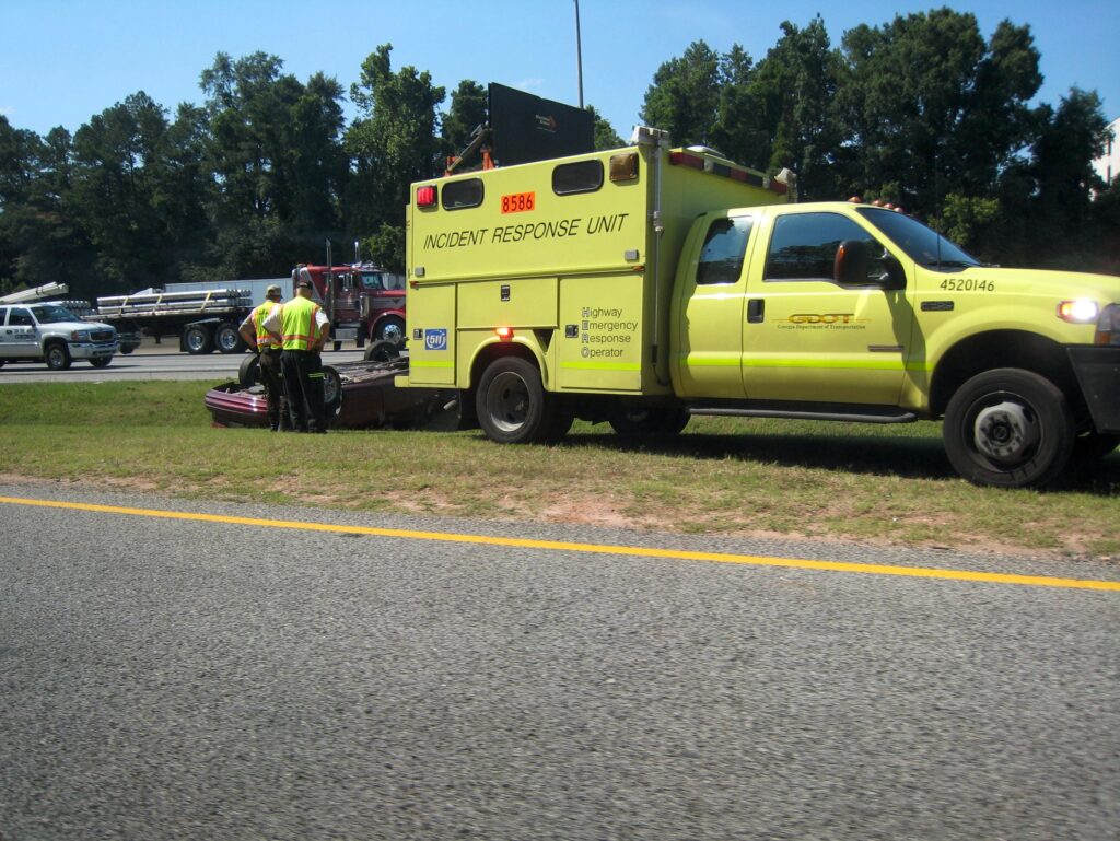
Complementing the system is GDOT’s network of highway emergency response operators (HERO). Driving large yellow trucks, these specially trained personnel quickly deal with wrecks and disabled vehicle incidents to minimize their impact on traffic flow. When not dealing with traffic emergencies, HERO units assist stranded motorists.
Other Transportation
Georgia’s transportation system also includes airports, public transit, railroads, and ports not directly operated by GDOT. In the state’s urban areas, public transportation is provided by 14 transit systems, the largest of which is MARTA. Much smaller in scale are 100 transit systems operated in rural areas to serve their residents.
In 2023 the state had 103 public airports listed in the state airport directory, including 95 commercial facilities that serve general aviation needs and scheduled air carriers. Airports in Albany, Athens, Atlanta, Augusta, Brunswick, Columbus, Macon, Savannah, and Valdosta provide regularly scheduled service by commercial air carriers.
Georgia has nearly 5,000 miles of railroad, predominantly operated by two large companies: CSX and Norfolk Southern. To help maintain light-density railroad routes important to the state’s rural areas, GDOT owns nearly 540 miles of rail lines that are leased to commercial operators. Rail passenger service provided by AMTRAK, the National Railroad Passenger Corporation, has stops in Atlanta, Gainesville, Jesup, Savannah, and Toccoa.
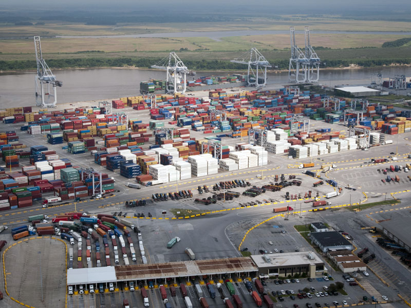
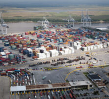
Deepwater ports are located in Savannah and Brunswick while inland terminals can be found in Bainbridge, Columbus, and Chatsworth. One of the busiest ports on the East Coast of the United States, Savannah handles approximately 80 percent of the ship-borne cargo entering Georgia. Specializing in automobile importing, Brunswick handles nearly all of Georgia’s remaining shipping traffic. These port facilities are operated by the Georgia Ports Authority.