Savannah’s remarkable city plan is distinguished from those of previous colonial towns by its repeated pattern of connected neighborhoods, multiple squares, streets, and designed expansion into lands held by the city (the common). It is unique in the history of urban planning in a number of respects, not the least of which is that the squares allow for more open space in Savannah than in any city layout in history.
Founded in 1733, Savannah is situated on a forty-foot-high bluff overlooking the Savannah River, eighteen miles from the Atlantic Ocean. Laid out by General James Edward Oglethorpe, it was the last colonial capital to be established by Britain in America.
Diversity within a Logical Framework
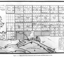
The basic plan unit is a ward, 600 feet to a side in the north-south direction, and 540 feet to 600 feet in the east-west direction. Streets and building lots are organized around a central open space or square. Each ward has a name. Wards were originally organized as urban neighborhoods with direct correlation to garden and farm lots in Oglethorpe’s expanded regional plan system.
The streets bounding the wards allow uninterrupted movement of traffic. Internal streets are interrupted by the squares to create a pedestrian-friendly scale. The resulting pattern features eight blocks to a ward. The larger four blocks on the north and south sides of the square are called tything blocks and are further divided by east-west lanes. Four smaller blocks front the squares on the east and west. These are called trust blocks. Tything blocks are subdivided into lots 60 feet in width that are sometimes further divided into increments of 20 or 30 feet, thereby creating a diverse pattern of building sizes and types.
Savannah’s plan reflects political and organizational considerations of the day. Each ward had tythingmen, who shared guard and other duties. Wards were tied to a larger regional plan of garden and farm lots. The repetitive nonhierarchal placement of wards, squares, and equal-sized lots points to the utopian ideals of the colony. The regularity of these lots controlled the size and rhythm of development in the third dimension to create a visually diverse and humanly scaled city.
Expansion by Replication
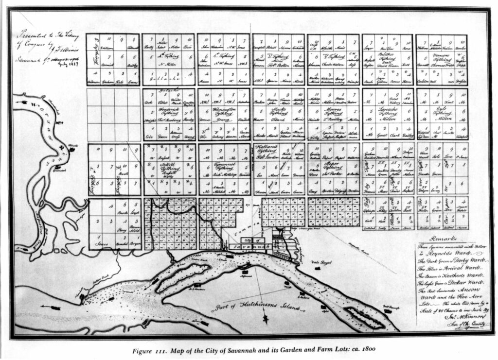
Equally important is the way the city grew between the American Revolution (1775-83) and the Civil War (1861-65). Until the mid-nineteenth century, the city plan was regularly expanded by the addition of wards into the common until a total of twenty-eight wards had been created. According to urban historian John Reps, “Savannah . . . used the power gained through municipal ownership of the common to shape growth in the public interest. The decisions to do so . . . produced America’s most unusual city plan.” All but four of these repeated wards had the characteristic squares.
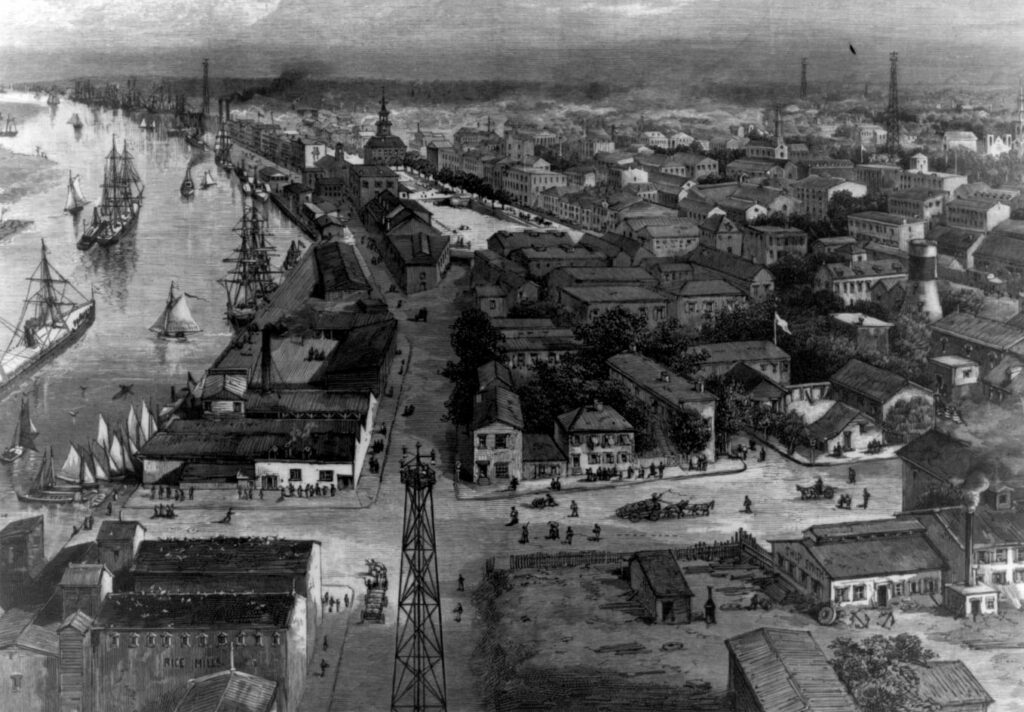
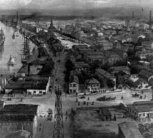
With the reclamation of Ellis Square in 2010, twenty-two squares remain, each approximately one acre in size. A park system also runs along the Savannah River on top of the bluff; Forsyth Park culminates the plan on the south while the intervening streets and avenues have center or side tree lawns. The result is an urban forest of unsurpassed beauty and utility. Savannah’s squares form a public outdoor extension of the restricted living space of the narrow urban lots. Many of the squares are further adorned by monuments commemorating various aspects of the city’s history.
Influence of the Plan
The Savannah plan influenced other settlement proposals, notably Ebenezer, Darien, Brunswick, and Radnor, South Carolina. It continues to provide inspiration, as shown in the 1993 creation of Bois-Franc, a 500-acre development in St. Laurent, Quebec. To create a flexible street/block pattern that would accommodate a range of densities and residential and recreational uses, the Canadian planners adapted the street grid of Savannah to allow development of individual but continuous neighborhoods.
The area of the original Savannah plan was included in a National Historic Landmark District designation in 1966. This district received further protection in 1973 when a Historic Review Board was established. The appointed members of the board see that the buildings surrounding the squares are visually compatible and appropriate in scale, and thus they define the plan.
As a synthesis of planning ideals that respond to social, military, environmental, and philosophical needs, the Savannah plan stands out among American colonial town plans. The plan continues to adapt favorably to contemporary needs by providing a model for new urban developments.
Savannah’s plan is among the most researched and analyzed in the history of American city planning. There are several theories about the influences and sources from which its distinctive layout was derived. John Reps sees it as a derivation of settlements established by the British in Northern Ireland in the seventeenth century, with which Oglethorpe was familiar. Other scholars still support the 1885 claim by Savannah historian William Harden that architect Robert Castell, a friend of Oglethorpe’s who later died in a debtors’ prison in London, England, provided Georgia’s founder with the inspiration for his plan. In his book Villas of the Ancients Illustrated (1728), Castell cited principles of the Roman architect Vitruvius that are directly reflected in Oglethorpe’s design. Other theories credit garden designs from the royal estates of George II or the new plan for London devised after the great fire of 1666 as significant influences on Savannah’s design.
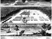
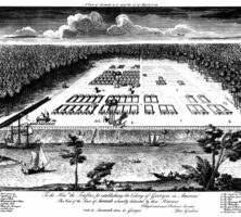
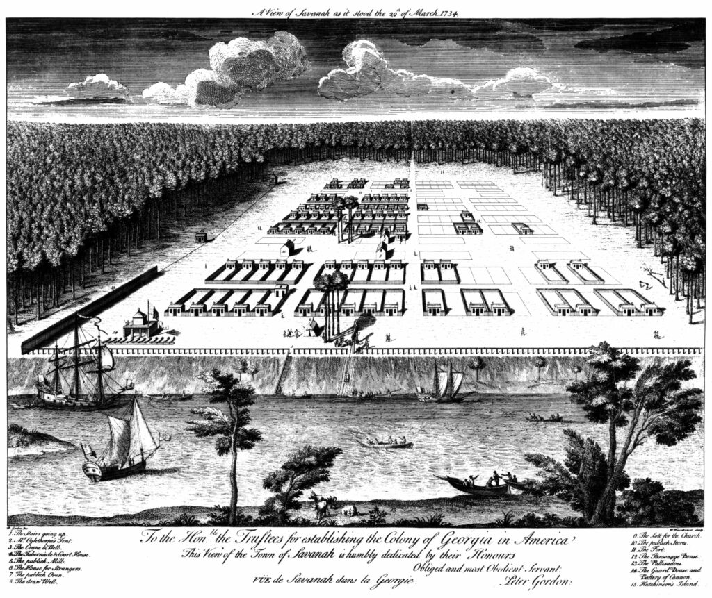
The first drawing of the plan, entitled “A View of Savannah as it Stood the 29th of March, 1734” is also the source of scholarly debate. There is widespread disagreement about what artist was responsible for this document and considerable speculation about the accuracy of the drawing.