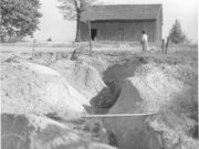
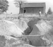
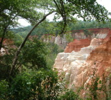
The washing away, or erosion, of Georgia’s topsoil is one of the most significant environmental disasters to occur in the state. Much of the land’s productivity, especially in the Piedmont, has been lost to erosion. Early in the twentieth century nearly 10 million acres were in cultivated row crops, and much of that land was losing soil in every rain. The Piedmont lost an average of about seven inches of its topsoil, but in many places all of it was lost. The resulting red hills were both the evidence and the heritage of generations of land mismanagement. In southwest Georgia spectacular gullies, such as Providence Canyon, permanently ruined much of the land for farming.
The agriculture that caused soils to wash away was part of a larger culture that prevailed across the South and much of the nation well into the twentieth century. Pioneer agriculture, which took place in an era when land was cheap, unlimited, and seemingly expendable, gave way to a combination of plantations, small farms, and eventually a sharecropper system that not only degraded the land but also kept farmers in debt and uneducated. Pioneers expanded westward when farmsteads lost their original fertility. Plantation owners viewed land as a tool to be used and discarded or laid by. Sharecroppers, like plantation owners, regarded land in the same way they viewed plows and mules—as an expendable tool for making a crop. The transiency of sharecopping added to this attitude; sharecroppers did not own the land they worked and seldom stayed longer than one or two years on a farm. Sharecropper agriculture was a persistent enemy of the land because it was such an enduring and widespread practice. As late as 1940, tenants operated around 60 percent of Georgia’s farms.
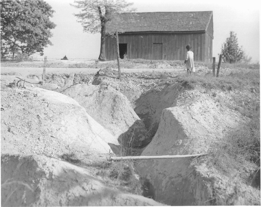
The erosion of so much topsoil from Georgia’s farms not only diminished the productivity of the soil but also filled the streams with silt and mud, swamping many lowland fields and filling millponds and lakes. An example of the effects of erosion-related silting occurred at a town called Scull Shoals, which grew and prospered in the early 1800s on the Oconee River south of Athens. A four-foot drop of water over the shoals powered the cotton mill that sustained the town. In the 1860s a ten-foot dam was built on top of the shoals to increase the waterpower. After the careless cotton agriculture of the late 1800s and early 1900s the river channel was so filled with soil runoff from the hills that the dam was completely buried and remains so today. Large and small reservoirs built elsewhere often filled with sediment within a few decades.
The sharecropping system lost its grip on Georgia agriculture in the middle of the twentieth century. The state experienced its worst drought in 1930-31, during the Great Depression, which worsened the already poor condition of Georgia’s soils. In the mid-1930s a federal law established the Soil Conservation Service to carry out programs to reduce erosion. In 1937 the Georgia General Assembly authorized the establishment of soil conservation districts (later called soil and water conservation districts). Working with the Soil Conservation Service, the conservation districts coordinated the planting of kudzu, building of terraces and farm ponds, improvement of pastures, management of forests and wildlife, and promotion of soil conservation education and incentive programs throughout the state.
These programs and other developments in agriculture began to decrease soil erosion by the 1950s. Most erosion occurs when rain falls on bare ground exposed by the tillage of cultivated crops. But increased use of such conservation practices as contour plowing, terracing, crop rotations, and later, “minimum tillage” or even “no tillage” has reduced erosion on cropland. Most crop cultivation has shifted from the highly erodible Piedmont to the less vulnerable Coastal Plain. And the amount of land under cultivation decreased from nearly 10 million acres early in the twentieth century to only about 3 million at the end.
The shifting of 6 or 7 million acres from cultivated cropland to forest and other nonerosive uses has made a dramatic change in the landscape. Farm ponds for conserving water and providing recreation dot the landscape. Forest acreage has increased since early in the twentieth century, and timber stands are thicker. Even the more than half-million acres of roadways and roadsides, which used to be subject to serious erosion, are now stabilized with pavement, grass, shrubs, and trees. Construction sites that previously included no precautions against erosion now have structures to protect the soil or catch soil that washes off before it reaches the streams.
In contrast to the rapid sedimentation of reservoirs early in the twentieth century, ponds and lakes filled so slowly in the second half of the century that little concern was shown for the consequences. A survey of Clark Hill Reservoir on the Savannah River in 1999 showed that “less than 0.3 percent of the total conservation storage” had been lost by silting in the forty-seven years since it was built. Lake Allatoona on the Etowah River silted at a rate of only 0.07 percent per year from 1949 to 1998; since the early 1980s the rate has been too low to measure.
Since the mid-twentieth century in Georgia the landscape, agricultural practices, and attitudes of its people have changed. The restoration of the bare, eroded hillsides, the silted streams, and the rutted and gullied roadsides represent signficant improvements.