The Georgia Piedmont lies between the Blue Ridge Mountains and the Upper Coastal Plain.
It is part of a larger area called the southern Piedmont, which is located in the southeastern and mid-Atlantic regions of the United States and is about 870 miles long and 60 to 190 miles wide. It runs in a northeast-to-southwest direction, following the main axis of the mountains, faults, and coastline of the southeastern United States. The southern Piedmont extends from Alabama and Georgia northeastward through South Carolina and North Carolina.
Boundaries
The boundary of the Piedmont on the southeastern side is the fall line, which generally separates the crystalline rocks of the Piedmont from the sedimentary rocks of the Atlantic Coastal Plain. In Georgia and the Carolinas the rivers mostly rise in the Piedmont and flow to the southeast, cutting through the metamorphic rocks that extend in the direction of the ocean underneath the sandy soils of the Coastal Plain. At the surface where Coastal Plain and Piedmont rocks are juxtaposed, the rivers may have waterfalls or rapids. In the early days of settlement by Europeans, these falls could interrupt travel. Sometimes it was necessary to stop at the falls, unload the cargo, and place it in warehouses, where it could be repackaged for shipment in small boats farther up the rivers. This meant that forts and houses were built at these locations, and the resulting “fall line cities” formed a consistent pattern of urban development across the region. In Georgia the important fall line cities are Augusta, Macon, and Columbus.
The boundary of the Piedmont on the northwest margin is the Blue Ridge Mountains. This margin is especially evident in the Carolinas and the part of Georgia approximately marked by the presence of the Brevard fault.
Geology
Geologists continue to study the origins of the rocks in the Piedmont province. The area is large and includes rocks ranging widely in age. The dynamic changes over time in this area are complex, but research has revealed the broad patterns of origin and development and specific structures in zones of special interest. The plateau of the Piedmont region has been formed largely on the edges of steeply upturned and altered rocks. Topographically, the Piedmont is made up of low hills and narrow valleys. The worn-down rocks of the Piedmont region pass below the sedimentary rocks of the Atlantic Coastal Plain for more than 150 miles from the fall line. The period of rise of the Appalachians was about 500 million years ago, at the end of the Cambrian Period.
A thick pile of variably metamorphosed sedimentary rocks from the late Precambrian Period to early Paleozoic Period mantle the basement rocks of the Piedmont. Several periods of volcanism have occurred, and the sedimentary rocks have been intruded by magma from deeper layers of the Earth, forming dikes and platons of granitic rocks and carrying important metals and minerals toward the surface. Gold was discovered in north Georgia in the early 1800s, and the race to find gold in the region near Dahlonega was the country’s first gold rush.
Rocks in the Piedmont are frequently overlaid by a thick layer of decomposed rock called saprolite, which is the red clay of Georgia. Saprolite is made up of clay minerals rich in silicon, aluminum, and some other elements, plus more or less pigmentary iron oxides and resistant minerals such as quartz. Saprolite is highly erodible if the vegetation cover of oak and hickory trees is removed. When the Piedmont was settled by Europeans, the removal of the mature forest and replacement of the vegetation with tobacco or cotton crops resulted in rapid erosion of the soil followed by reduction in yield of the crops. Fields were sometimes abandoned after only a few years of cultivation. Forests dominated by pine trees, today used for paper products, later regrew on these sites.
The different soil, derived from a different geologic history and supporting a different vegetation, produces the two major geographical provinces of Georgia, the Piedmont and the Coastal Plain.
Vegetation
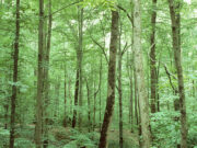
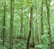
The original forests of the southern Piedmont consisted of oak and hickory trees. One of the very few stands of original forest remaining is located at Fernbank Forest in Atlanta. In this forest pine trees are relatively uncommon, while yellow poplars (Liriodendron tulipifera) make up 20 percent of the forest trees and are large, exceeding 50 centimeters in diameter. White oak (Quercus alba), northern red oak (Q. rubra), black oak (Q. velutina), and post oak (Q. stellata) are important on mesic sites, together with several species of hickories (Carya glabra, C. tomentosa, and C. cordiformis).
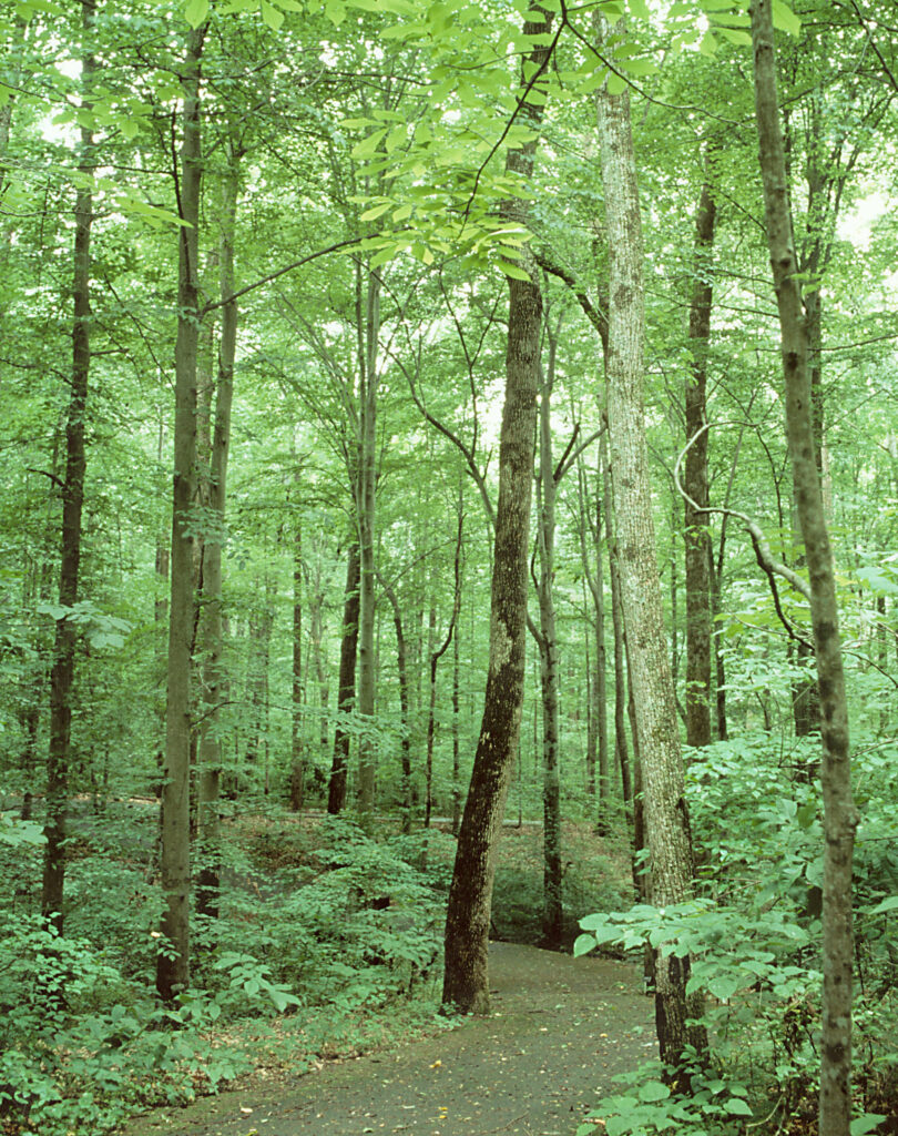
Courtesy of Fernbank Science Center
Native American Settlement Patterns
Native American peoples moved into Georgia about ten thousand years ago. The region was colonized by small bands that had a technology and strategy of mobility that enabled them to inhabit the late Pleistocene environments of the region. Eventually, more advanced Mississippian cultures using corn agriculture in or near floodplains developed, by about A.D. 1200. These cultures, with their complex social structures, made palisade villages with ceremonial mounds and grew corn.
The journals of the Spanish explorer Hernando de Soto, who traveled across Georgia in 1540, describe the towns and the countryside on his route up the Flint River from Florida, across the Ocmulgee, Oconee, and Little rivers to the Savannah River and then into the Carolinas. At this time there were several chiefdoms present, with hierarchical village patterns and tribute systems in the region. In the more northern part of the Piedmont, the rivers are narrow and the floodplains are restricted in width, making them less suitable for large villages.
European Settlement Patterns
Later European settlers judged the fertility and richness of the soil from its color and the amount and type of its vegetation, and they tried to establish homesteads in the best places according to these criteria. In the lower portions of the Piedmont, the soils were a little richer, and the topography was less rugged. Cotton plantations and dairy farming came to characterize and dominate the area. Small subsistence farmers settled in the more northerly part of the Piedmont, where the soils were poorer, and the topography was steep and rough. Later poultry and hog production became important agricultural activities in the area.