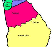
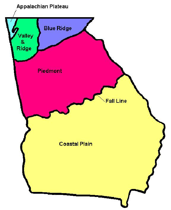
The Coastal Plain is the youngest of Georgia’s geologic provinces, making up almost half the state’s surface area. The province begins at the fall line, which runs from Augusta through Macon to Columbus, and extends eastward all the way to the modern Georgia coast and southward to the Florida state line. The Coastal Plain is composed of undeformed sedimentary rock layers whose ages range from the Late Cretaceous to the present Holocene sediments of the coast.
Photograph by Pamela J. W. Gore
Geologic Features
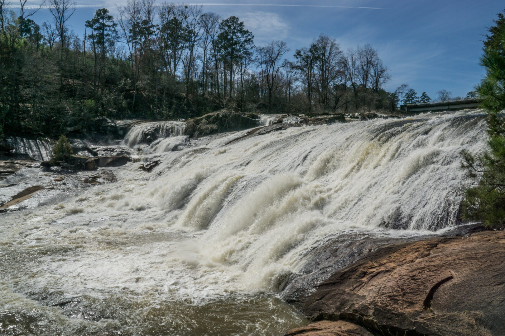
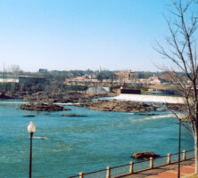
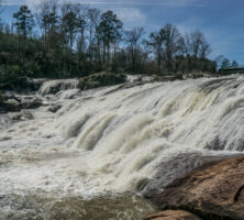
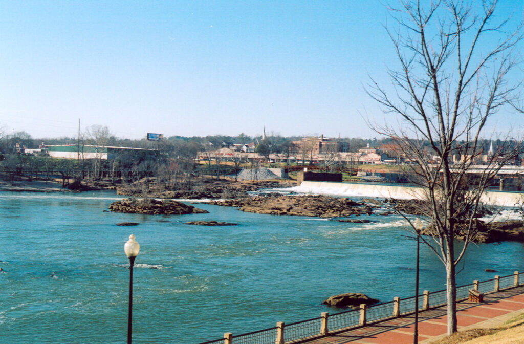
The fall line marks the beginning of the Coastal Plain and represents the place where the younger sedimentary rocks of the Coastal Plain rest atop the much older rocks of the Piedmont geologic province. The fall line, so called because it is marked by waterfalls, rapids, and whitewater, formed where streams flow off the hard, erosion-resistant rocks of the Piedmont onto the softer, easily eroded sediments of the Coastal Plain. Since streams can erode more deeply into the soft Coastal Plain rocks than they can into hard Piedmont rocks, the result is steeper stream gradients and waterfalls.
Beneath Coastal Plain sediments are harder igneous and metamorphic rocks, such as those found in the Piedmont. Usually referred to as the “basement,” these hard rocks occur at greater and greater depths toward the south and east, reaching depths of up to 10,000 feet or more beneath the modern Georgia coast. Coastal Plain rocks, then, essentially form a large, wedge-shaped mass, which is thickest along the modern coast and the Florida state line and thinnest along the “feather-edge” of the fall line. Deposits of Georgia’s Coastal Plain extend with little change into South Carolina to the east and Alabama to the west.
Coastal Plain sediments occur as layers, or strata, that incline gently into the subsurface toward the south in west Georgia and toward the east in eastern parts of the state. Because of this, the oldest Coastal Plain strata seen at the surface occur right at the fall line and are covered by increasingly younger layers to the south and east. These rock layers record the long history of the Coastal Plain and show that sea level has risen and fallen many times during the last 100 million years. When sea level was high, a shallow seaway covered much or even all of the Coastal Plain. During times of lower sea level, the area was dry land, with large rivers and broad floodplains. For this reason, Coastal Plain strata consist of alternating marine sediments (those deposited in the sea) and nonmarine sediments (those formed on land).

Image from Stephen Rahn
There are several large-scale geologic features of the Coastal Plain in Georgia that have influenced’s long history. Running southeastward through the center of the Coastal Plain is the central Georgia arch. This arch is characterized by relatively thin sedimentary layers, as compared to the thickness of strata in both southwest and east Georgia. Eastward from the arch, the Coastal Plain strata thicken, forming the southeast Georgia basin. This sedimentary basin is actually part of the Atlantic Coastal Plain, and its geologic history is closely related to that of the Carolinas. Likewise, west of the central Georgia arch is the southwest Georgia basin. Its geologic story is similar to that of the eastern Gulf Coastal Plain and has much in common with strata in Alabama. The origin of these features lies in the nature of the ancient crust beneath Coastal Plain layers (the basement). Areas of thinner strata, like those in the central Georgia arch area, reflect strong, thick crust which sank only a little under the weight of the sediments; the result was that sediments in this area never accumulated to any great thickness. In the basin areas, however, the underlying crust was weaker and thinner, allowing it to be pushed beneath the strata’s weight so that more and more sediments could be deposited.
One last feature about the history of Georgia’s Coastal Plain deserves mention. During all of Late Cretaceous and early Paleogene time, Florida looked much like the Grand Bahama Bank does today: a marine platform mostly covered by shallow seas with small, low islands scattered here and there. The sediments that accumulated in those shallow waters formed the limestone deposits that underlie much of Florida. Also like the modern Bahamas, the Florida banks were separated from mainland Georgia by a deep oceanic strait called the Sewanee Strait, so that the shoreline wrapped around the southern part of Georgia during this period. As a result, Coastal Plain areas near the fall line contain sediments formed in estuaries, deltas, barrier islands, coastal mud flats, and sandy beaches. Further south, Coastal Plain strata contain fossil-bearing sediments that formed in the shallow offshore waters of the continental shelf.
Courtesy of Pamela J. W. Gore
The Hidden Triassic and Jurassic
The earliest history of Georgia’s Coastal Plain begins with the breakup of the supercontinent Pangaea during the later part of the Triassic period. As North America broke apart from Pangaea, deep troughs were formed along the line of separation; into these troughs were deposited thick layers of coarse red sandstones, conglomerates, shales, and other nonmarine sediments. Similar sediment-filled troughs (called rift valleys) occurred all along North America’s east coast, from Georgia to Nova Scotia, Canada. They probably were similar to the modern East Africa Rift System.
Based on this analogy, as well as on the nature of the preserved Triassic and Jurassic sediments themselves, scientists believe that these long, deep troughs were volcanically active, with hot springs and other hydrothermal (or hot water) features, broad lakes and swamps, and river plains and forests. (Coal deposits of Triassic–Jurassic age in a Virginia rift trough were the very first coals mined in America.) Some of the earliest dinosaurs roamed across these valleys: well-preserved vertebrate fossils are found in Virginia rift deposits, and world-famous dinosaur tracks and trackways are found in the Connecticut rift valley.
Photograph by Pamela J. W. Gore
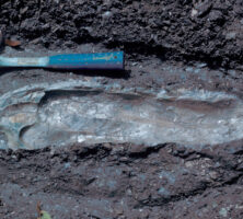
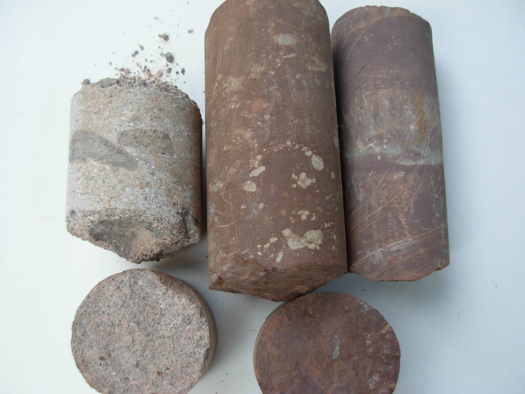
Many of these sediment-filled rift valleys in eastern North America may be seen directly at the surface (in Connecticut, Massachusetts, North Carolina, Nova Scotia, Pennsylvania, South Carolina, and Virginia). Georgia’s Triassic rocks are not exposed at the surface but rather are found deeply buried beneath younger Coastal Plain layers. Their presence was determined both by seismic profiling and by deep drilling, which recovered cores from these rocks. Samples from those cores reveal types of rocks similar to those seen at the surface farther north in the Carolinas.
By the early part of the Jurassic period, full-scale continental separation had taken place, and a new, narrow ocean basin was opening along North America’s East and Gulf coasts. Very thick deposits of sediments formed in coastal and shallow marine settings during this time in Georgia, as well as in the rest of eastern and southern North America. These Jurassic deposits are buried deeply beneath younger layers, hidden like the Triassic rocks, over almost all this area. Indeed, the existence of the Jurassic deposits was entirely unsuspected until they were detected by seismic profiling.
Also buried in the subsurface of the Coastal Plain are Lower Cretaceous strata, detected by seismic profiling and deep drilling. Like the Jurassic deposits beneath them, the Lower Cretaceous rocks formed generally in shallow marine, coastal, and nonmarine settings.
Late Cretaceous Strata
The oldest sedimentary strata of Georgia’s Coastal Plain that are seen on the surface are of Late Cretaceous age. They occur immediately south of the fall line in the Chattahoochee Valley area of southwest Georgia and may be found almost all the way to Macon. In more eastern parts of the state, Late Cretaceous strata are covered over by younger layers but are still present in the subsurface. Where they are exposed, Late Cretaceous rocks are composed of sediments that formed mainly in coastal settings, with alternating layers of nonmarine and marine strata showing that the area experienced repeated, long-term sea-level fluctuations that lasted all through the Late Cretaceous.
Photograph by David R. Schwimmer
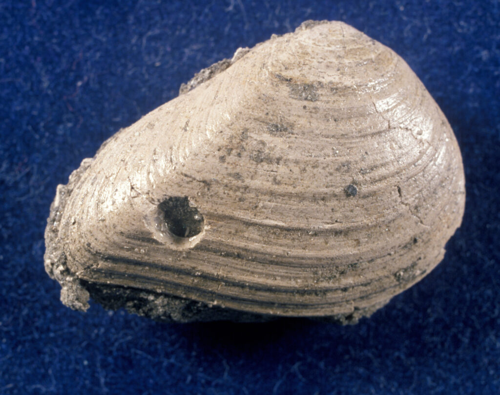
During most of this time, the Central Georgia uplift was dry land, and strata of this age in the central part of the state are mainly composed of nonmarine sandstones, conglomerates, and mudstones. These Late Cretaceous rocks in central Georgia are called the Buffalo Creek Formation and are mostly unfossiliferous (meaning that they contain no fossils). Strata of the same age in the westernmost parts of the state contain abundant fossils of such marine animals as clams, oysters, and others, indicating a marine origin for this layer. Indeed, farther over into Alabama, rocks of exactly the same age show evidence of having formed in deeper waters of an offshore continental shelf. Thus, the general geography of the eastern Gulf Coastal Plain during much of the Late Cretaceous involved a shallow seaway over most of the Alabama Coastal Plain and dry land in central Georgia.
Late Cretaceous strata in the Chattahoochee Valley region are composed of six different formations. Oldest among these is the Tuscaloosa Formation. Named for rocks around Tuscaloosa, Alabama, the formation is found immediately south of the fall line. It is composed mainly of sandstone layers alternating with layers of mudstone. Very few fossils are found in Georgia’s part of the Tuscaloosa, and the ones that are found are mostly pieces of petrified wood, suggesting a dry-land setting. The Tuscaloosa’s sediments, too, show evidence of having been formed on land and are generally interpreted as having formed in stream and floodplain settings.
The top of the Tuscaloosa is cut by an erosional surface (or unconformity), indicating that a very long period of time elapsed before the development of the next younger formation. Indeed, two major time intervals of Cretaceous and a part of a third are missing between the Tuscaloosa layer and the layers of the next overlying formation, called the Eutaw Formation.
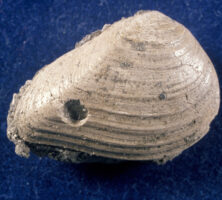
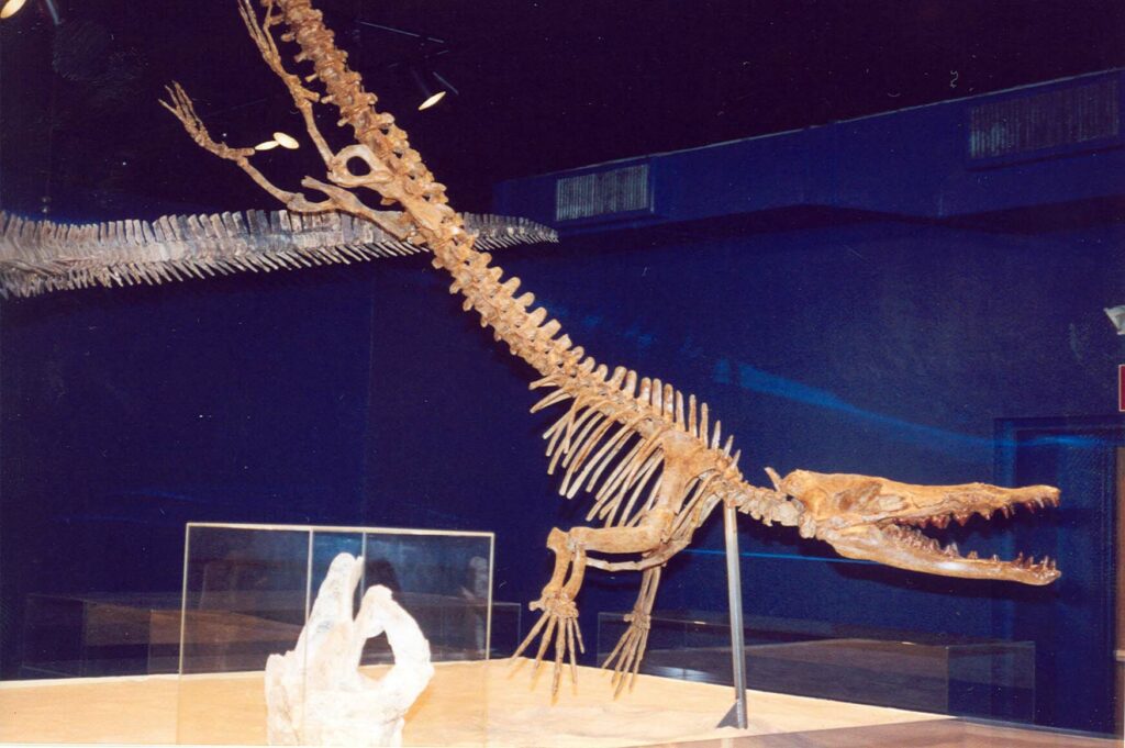
The Eutaw Formation, named for Eutaw, Alabama, lies over the Tuscaloosa. It is the first Late Cretaceous formation in west Georgia to have formed along the coast. Eutaw layers west of Macon show evidence of formation in river systems, whereas those near the Alabama state line formed in estuaries, tidal marshes, lagoons, and barrier islands, with sediments similar to those found in the Panama City area of the Florida panhandle. These coastal Eutaw deposits are richly fossiliferous, containing numerous invertebrate fossils of ammonites, clams, oysters, and snails, as well as vertebrate remains, notably fish bones and sharks’ teeth. In addition, bones from a pterosaur (a flying reptile) have also been reported from the Eutaw. Recently, a shale layer in the Eutaw was found to contain remarkably preserved dinosaur feathers and other preserved soft-tissue fossils.
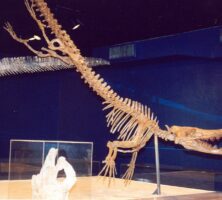
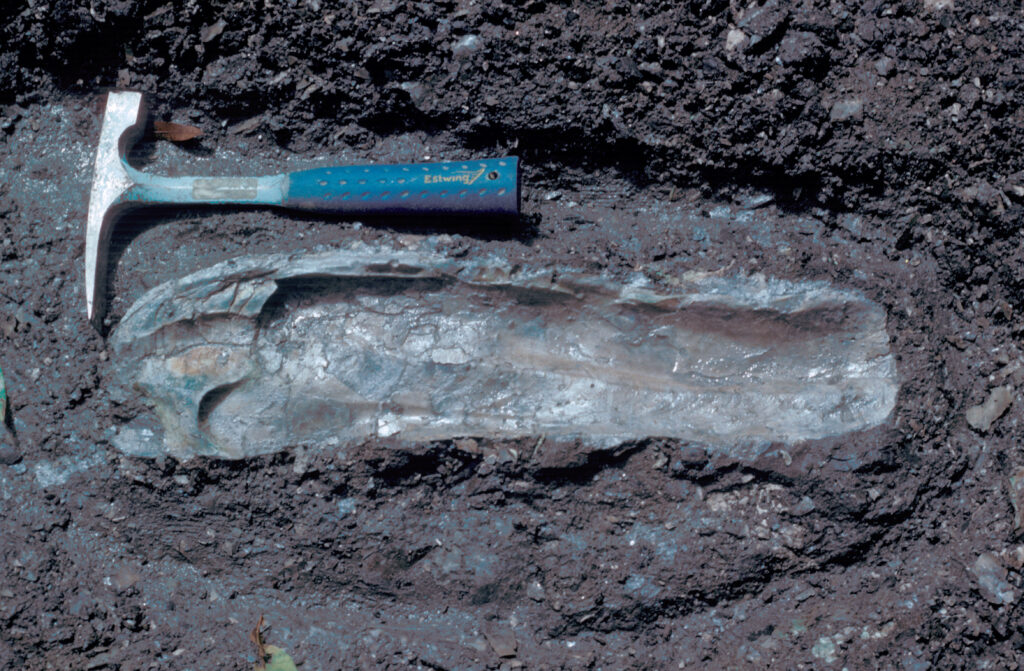
Overlying the Eutaw is the Blufftown Formation. Similar to the Eutaw, the Blufftown Formation formed at the coast. It contains sediments that were deposited in a broad estuary with large sand shoals near its mouth and extensive, muddy tidal flats along its sides. Farther to the west, Alabama deposits of the same age are mainly chalks (for example, the Mooreville Chalk) that settled out of seawater on the continental shelf. The Blufftown is the thickest Cretaceous unit in the Chattahoochee Valley region and is composed mainly of coarse sandstones and thinner layers of mudstone in its northern areas, and mudstones and shales further south. Blufftown deposits are also highly fossiliferous and have yielded large numbers of Cretaceous ammonites, clams, marine snails, oysters, and other invertebrates. Its vertebrate fossils are even more interesting and include bones of giant crocodiles, duckbill dinosaurs, and in Alabama, a tyrannosaur-type dinosaur.
Photograph by David R. Schwimmer
Above the Blufftown lies the Cusseta Formation. Like the Eutaw and Blufftown before it, the Cusseta represents formation in a coastal complex of estuaries, barrier islands, tidal marshes, lagoons, and shallow inner–continental shelf locales. It, too, is richly fossiliferous.
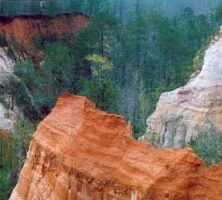
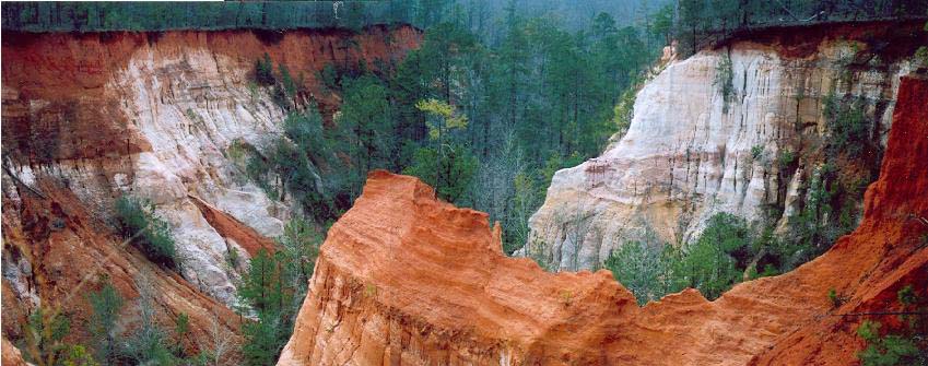
The youngest Late Cretaceous formations of west Georgia are the Ripley Formation and the Providence Sand. Both of these units are similar to the Eutaw, Blufftown, and Cusseta formations in the kinds of sediments they contain and the way in which they were formed. The Providence may be seen beautifully exposed in the walls of Providence Canyon, known as “Georgia’s Little Grand Canyon,” in Stewart County.
Although the Providence Sand is uppermost Cretaceous in age, an erosional surface truncates its top, so that no rocks exist in Georgia that record the end of the Cretaceous. This is unfortunate because it means that no deposits recording the meteorite impact hypothesized to have caused the extinction of the dinosaurs are exposed in the state. Elsewhere on the Gulf Coastal Plain (near Braggs, Alabama, for example), layers of the right age do occur and have been studied by scientists from all over the world.
Paleogene Strata
With the exception of the Cretaceous rocks of the Chattahoochee Valley, the rest of Georgia’s Coastal Plain strata are of the Paleogene period, which includes the Paleocene, Eocene, and Oligocene epochs. Although they cover much more area than Cretaceous strata, Paleogene rocks show many of the same patterns: nonmarine and coastal sediments in central Georgia and deeper-water marine sediments in both eastern and western parts of the state. Also like the Cretaceous, Paleogene strata show the effects of repeated sea-level fluctuations throughout their history.
Photograph by Pamela J. W. Gore
Several of these Paleogene units act as major aquifers for south Georgia and north Florida. Additionally, Paleogene units in Georgia contain important commercial deposits of kaolinite clay and bauxite.
Paleocene Epoch Formations
Paleocene strata in Georgia are best exposed in the western part of the state, where they form several important groups of formations. The first of these is the Midway Group, composed of the Clayton and Porters Creek formations. The Clayton Formation lies directly on top of the erosional surface (unconformity) that cuts off the top of Cretaceous layers in Georgia. In western parts of the state, the Clayton is a fossil-bearing limestone that formed in the shallow sea covering most of south Georgia at that time. These limestones are highly permeable and form a major aquifer system in west Georgia and east Alabama. To the east, in the Americus area, the Clayton is made up mostly of dark clays and fossil-bearing marls (or loose deposits), which formed closer to the shore.
Above the Clayton in the westernmost areas of Georgia is the Porters Creek Formation, a relatively thin deposit composed mainly of dark gray clay shales. The Porters Creek thickens westward into Alabama but is not found any farther east than Americus. An erosional surface at the top of the Porters Creek Formation suggests that it may have originally been larger but was eroded away before formation of the upper Paleocene layers above it.
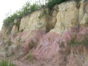
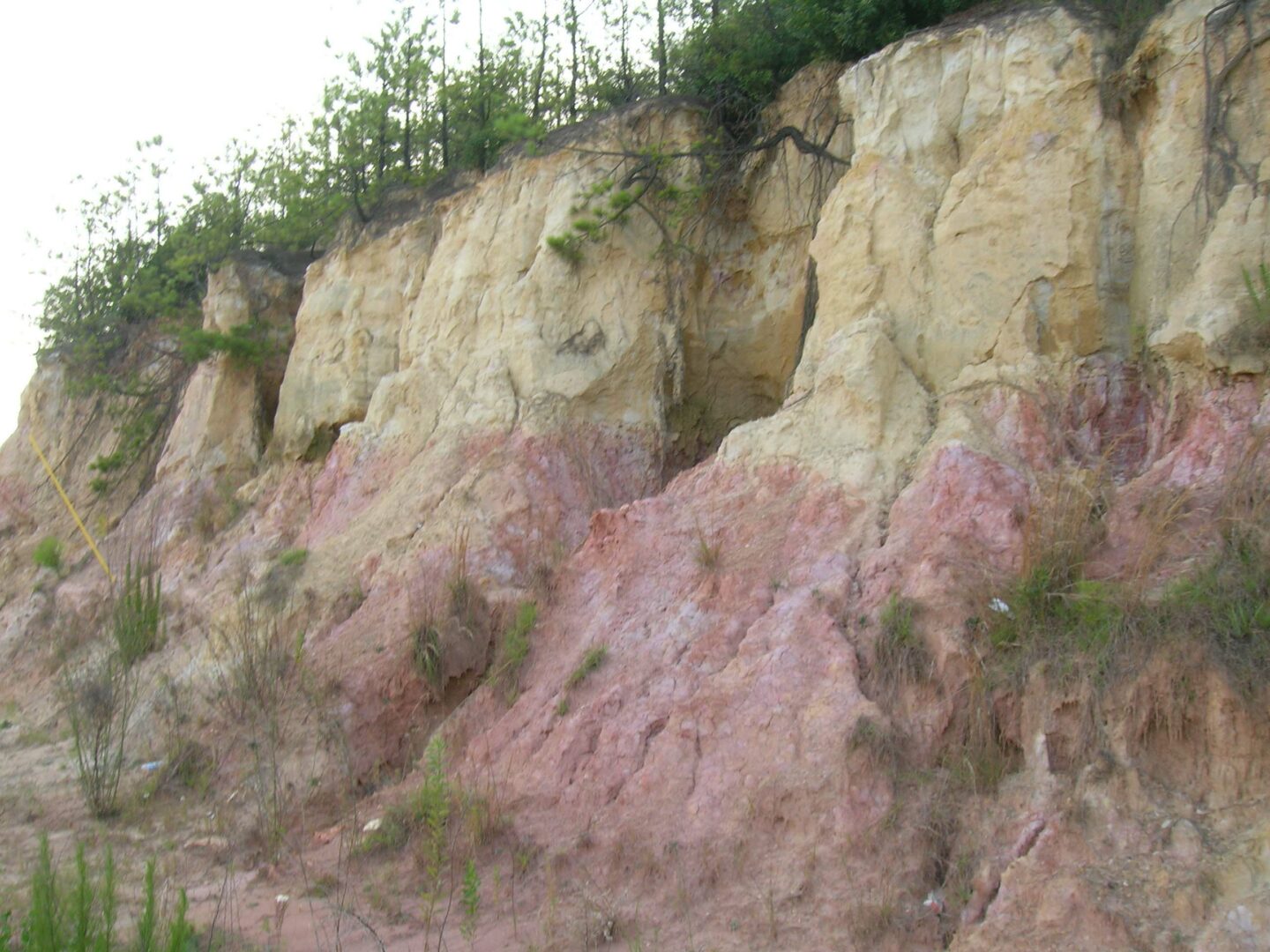
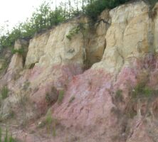
In middle Georgia, Paleocene-age layers are included in the lower Huber Formation. The Huber is a complex unit whose oldest layers lie on top of Cretaceous Buffalo Creek deposits and whose youngest beds are of middle Eocene age. Huber sediments are mainly nonmarine deposits consisting of sands and kaolinite clay, thought to have formed in broad-stream and floodplain systems. Huber kaolinites are similar to those of the Buffalo Creek and together form the backbone of Georgia’s important kaolin industry.
The other Paleocene group, the Wilcox, rests on top of Midway layers and contains the Baker Hill, Nanafalia, and Tuscahoma formations of the Paleocene, as well as the Hatchitigbee Formation of the Early Eocene. The Baker Hill Formation is a coarse-grained, cross-bedded sandstone with evidence of formation along a tidally dominated coastline. The Nanafalia Formation is of the same age as the Baker Hill but formed in deeper waters farther to the south. Made up of coarse, fossil-bearing sandstone with local thin clay beds, the Nanafalia consists in the Americus area of sands and clay that formed in river and coastal settings. In some areas, the Nanafalia also contains deposits of bauxite, some of which are large enough to be commercially important.
Overlying the Baker Hill is the Tuscahoma Formation. It is composed mainly of clay, silt, and fine sand layers that probably formed in the quiet waters of a broad tidal flat or shallow lagoon.
Eocene Epoch Formations
The shallow sea in which Paleocene sediments were formed continued into Eocene time, and most layers of that age in Georgia were formed either in the shallow sea in the southern part of the state or in coastal areas farther north. In this shallow Eocene sea lived the primitive whale Georgiacetus, which represents a very early stage in whale evolution and whose hind legs and hips were still functional. Sediments of the clay-rich Huber Formation continued to form in central Georgia.
Photograph by Pamela J. W. Gore
The oldest Eocene layers are also part of the Wilcox Group. They are represented mainly by the Hatchitigbee Formation, a fine-grained sandstone with clay layers and abundant marine shells of animals that lived near the shore. The top of the Hatchitigbee is cut off by another erosion surface.
Middle Eocene layers, most of which are marine or coastal in origin, are found in west central Georgia and compose the Claiborne Group. From bottom to top, the Claiborne contains the Tallahatta, Lisbon, and McBean formations. The Tallahatta Formation is mainly composed of sandstone and clays that probably formed on land in river systems. Above the Tallahatta is the Lisbon Formation, composed mainly of fossil-bearing clays, fine sands, and limestones that formed as the gradually rising sea level caused the sea to flood over the nonmarine Tallahatta. The McBean Formation in east Georgia consists of fossiliferous fine sand and marl. A famous fossil-collecting site on the Savannah River, known as Shell Bluff, is part of the McBean Formation. In the westernmost parts of the Georgia Coastal Plain are fossil-bearing layers of the Avon Park Limestone, which is the same age as the Claiborne and represents more open-marine, continental-shelf conditions.
The Late Eocene was a time of high sea levels, with marine layers over most of the Georgia Coastal Plain. The Ocala Limestone in the Dougherty Plain region of southwest Georgia is a fine-grained, white or cream-colored, fossil-bearing limestone. It is believed to have formed in the quiet, open waters of the continental shelf far from land. The Ocala is very permeable and, along with the Avon Park beneath it and the Suwannee Limestone above it, forms the Upper Floridan aquifer, one of the most productive aquifers in the United States. Because limestone rock is soluble in rainwater and groundwater, the area where the Ocala is found often shows features of karst topography, a type of landscape typified by numerous sinkholes, small lakes, and caverns.
In central and east Georgia, layers of the same age as the Ocala form the Barnwell Group and represent nearshore and coastal conditions. The oldest Barnwell formation is the Clinchfield Sand. In east central Georgia, where it formed in shallow, coastal waters, the Clinchfield is composed of clean quartz; farther to the east, it has some limestones and probably represents offshore conditions. On top of the Clinchfield are the highly fossiliferous layers of the Tivola Limestone, which is considered to be an extension of the Ocala during maximum high sea level of the Late Eocene. The Twiggs Clay and Irwinton Sand rest on top of the Tivola. They formed in shallower water as sea level fell and the shoreline moved southward.
Photograph by Pamela J. W. Gore
The Barnwell Group contains many different formations because sea level during the Late Eocene changed rapidly, causing the shoreline’s position to advance and retreat and leaving a complex interlayering of coastal and shallow-marine sediments. The layers at the top of the Barnwell are named the Tobacco Road Sand and are believed to represent the soil that formed at the end of the Eocene, after sea level fell and much of the Coastal Plain was exposed to erosion.
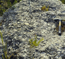
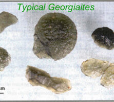
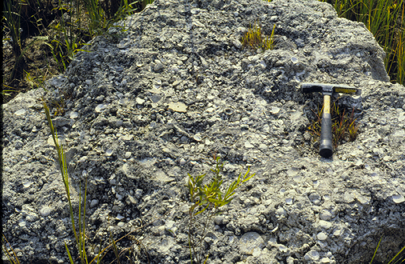
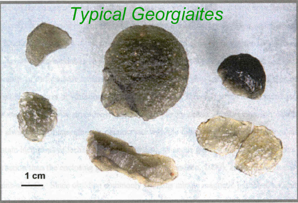
Some areas of the Coastal Plain contain tektites, small pieces of glassy material that probably formed by the sudden melting of rock in a meteorite impact. Such an impact hit in the area of the Chesapeake Bay during the Late Eocene, and tektites from that blast can be found in deposits of the same age in Georgia, where they are known as georgiaites.
Oligocene Epoch Formations
In east and central Georgia’s Coastal Plain, layers of Oligocene age consist mainly of the Suwannee Limestone. The Suwannee is mostly a light-colored, fossil-bearing, granular limestone. It formed in the warm tropical waters of the south Georgia seaway. In some areas, Suwannee rocks are now composed of the siliceous rock, chert. It probably formed by a chemical reaction in which silica in groundwater replaced the original limestone. Some of these cherts were highly prized by Native Americans as material for arrowheads, stone axes, or other implements. The Suwannee overlies the Avon Park and Ocala limestones and with them forms the Floridan aquifer system.
The south Georgia seaway, whose history stretches back at least as far as the Cretaceous, gradually became narrower and shallower and by the end of the Oligocene was gone, ending the formation of shallow-marine sediments over most of the state.
Youngest Formations
Over most of the Coastal Plain, sediments of Miocene and younger ages are mostly composed of nonmarine deposits and constitute a complex association of deposits formed in streams, swamps, and floodplains. In many areas, these deposits are red-colored clays, sands, and gravels found directly at the surface; they are thought to be soils formed by weathering after the south Georgia sea withdrew for the last time at the end of the Oligocene. These deposits vary from place to place and are generally named the Altamaha Formation. In east Georgia and South Carolina, the Altamaha consists of gravels, coarse-to-fine sandstones, and mudstones. In eastern areas of the Coastal Plain, the formation contains sharks’ teeth and other fossils indicating that it formed in the shallow waters just offshore, but over most other parts of the south Georgia Coastal Plain, the Altamaha is nonmarine and contains well-preserved fossils of land-dwelling organisms.
Although most Miocene sediments in Georgia are considered to be the Altamaha Formation, several other names are used locally, such as the Marianna Formation of northwest Florida and Georgia, and the Hawthorne Formation in south Georgia.
Photograph by Edward Albin
Sedimentary deposits formed during the Pleistocene epoch, or Ice Ages, are found mainly near the modern shore. Their history involves the rising and falling of sea level due to the advance and retreat of the giant continental glaciers.